Santa Cecilia geodata
Santa Cecilia (Castille and León) is a seat of a third-order administrative division; located in Spain in Europe/Madrid (GMT+2) time zone. With population of 117 people, there are 5732 cities with bigger population in this country. Compared to other cities in Spain, 75.2% of cities are located further ↓South; 56.8% of cities are located further →East and 73.7% of cities have lower elevation than Santa Cecilia. Note1
Administrative division(s):
- Level 1: Castille and León
- Level 2: Provincia de Burgos
- Level 3: Santa Cecilia


Santa Cecilia GPS coordinates[2]
42° 3' 8.1" North, 3° 48' 12.42" West
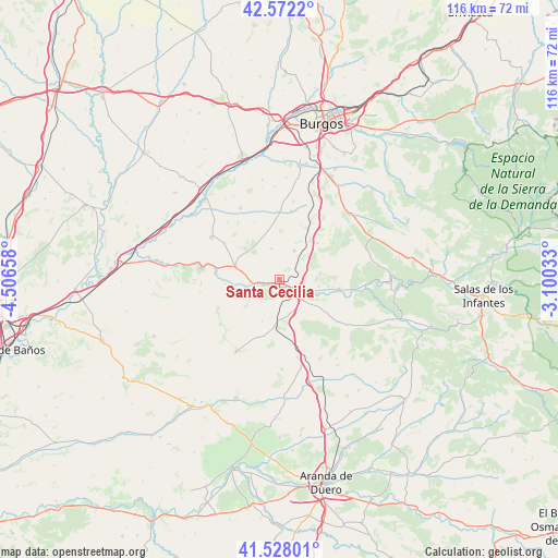
| Map corner | latitude | longitude |
|---|---|---|
| Upper-left | 42.5722°, | -4.50658° |
| Center: | 42.05225°, | -3.80345° |
| Lower-right: | 41.52801°, | -3.10033° |
| Map W x H: | 116.1×116.1 km | = 72.1×72.1mi |
| max Lat: | 43.74134° ⇑24.8% North |
| Santa Cecilia: | 42.05225° |
| min Lat: | ⇓75.2% South 27.64134° |
| min Long | Santa Cecilia | max Long |
| -18.00367° | -3.80345° | 4.2899° |
| W 43.2%⇐ | ⇒56.8% E |
Elevation
Elevation of Santa Cecilia is 841 m = 2759 ft, and this is 243 m = 797 ft above average elevation for this country.
| Max E: |
1682 m = 5518 ft | 26.3% |
| Santa Cecilia | 841 m 2759 ft | |
| Avg. | 598 m = 1962 ft | |
Min E: |
0 m = 0 ft | 73.7% |
See also: Spain elevation on elevation.city.
Geographical zone
Santa Cecilia is located in North temperate zone (between Tropic of Cancer and the Arctic Circle). Distance of this Northern Tropic circle is 2069.9 km =1286.2 mi to South.| Distance of | km | miles | from Santa Cecilia |
|---|---|---|---|
| North Pole | 5331.3 | 3312.7 | to North |
| Arctic Circle | 2725.4 | 1693.5 | to North |
| Tropic Cancer | 2069.9 | 1286.2 | to South |
| Equator | 4675.8 | 2905.4 | to South |


Nearby cities:
15 places around Santa Cecilia: (largest is in red/bold)
• Avellanosa de Muñó
7.9 km =4.9 mi,  193°
193°
• Fontioso
13.3 km =8.3 mi,  156°
156°
• Iglesiarrubia
9.4 km =5.8 mi,  202°
202°
• Lerma
4.6 km =2.9 mi,  128°
128°
• Madrigalejo del Monte
10.3 km =6.4 mi,  38°
38°
• Mahamud
13.6 km =8.5 mi,  303°
303°
• Quintanilla de la Mata
7.7 km =4.8 mi, 157°
• Santa Inés
8.4 km =5.2 mi,  99°
99°
• Tordómar
5.1 km =3.2 mi,  262°
262°
• Torrecilla del Monte
10.2 km =6.3 mi,  62°
62°
• Villahoz
9.4 km =5.8 mi,  286°
286°
• Villalmanzo
5.1 km =3.2 mi,  94°
94°
• Villamayor de los Montes
6.7 km =4.2 mi,  27°
27°
• Villaverde del Monte
12.1 km =7.5 mi,  355°
355°
• Zael
6.3 km =3.9 mi,  342°
342°
Sources, notices
• [Note1] Compared only with cities in Spain existing in our database
• [Src1] Map data: © OpenStreetMap contributors (CC-BY-SA)
• [Src2] Other city data from geonames.org with taken over terms of usage.
• [Src3] Geographical zone / Annual Mean Temperature by Robert A. Rohde @ Wikipedia
