Villahoz geodata
Villahoz (Castille and León) is a seat of a third-order administrative division; located in Spain in Europe/Madrid (GMT+2) time zone. With population of 340 people, there are 4347 cities with bigger population in this country. Compared to other cities in Spain, 75.8% of cities are located further ↓South; 58.4% of cities are located further →East and 72.7% of cities have lower elevation than Villahoz. Note1
Administrative division(s):
- Level 1: Castille and León
- Level 2: Provincia de Burgos
- Level 3: Villahoz


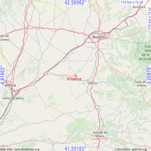
Villahoz GPS coordinates[2]
42° 4' 33.132" North, 3° 54' 46.44" West
| Map corner | latitude | longitude |
|---|---|---|
| Upper-left | 42.59562°, | -4.61603° |
| Center: | 42.07587°, | -3.9129° |
| Lower-right: | 41.55183°, | -3.20978° |
| Map W x H: | 116.1×116.1 km | = 72.1×72.1mi |
| max Lat: | 43.74134° ⇑24.2% North |
| Villahoz: | 42.07587° |
| min Lat: | ⇓75.8% South 27.64134° |
| min Long | Villahoz | max Long |
| -18.00367° | -3.9129° | 4.2899° |
| W 41.6%⇐ | ⇒58.4% E |
Elevation
Elevation of Villahoz is 832 m = 2730 ft, and this is 234 m = 768 ft above average elevation for this country.
| Max E: |
1682 m = 5518 ft | 27.3% |
| Villahoz | 832 m 2730 ft | |
| Avg. | 598 m = 1962 ft | |
Min E: |
0 m = 0 ft | 72.7% |
See also: Spain elevation on elevation.city.
Geographical zone
Villahoz is located in North temperate zone (between Tropic of Cancer and the Arctic Circle). Distance of this Northern Tropic circle is 2072.5 km =1287.8 mi to South.| Distance of | km | miles | from Villahoz |
|---|---|---|---|
| North Pole | 5328.7 | 3311.1 | to North |
| Arctic Circle | 2722.8 | 1691.9 | to North |
| Tropic Cancer | 2072.5 | 1287.8 | to South |
| Equator | 4678.4 | 2907 | to South |


Nearby cities:
15 places around Villahoz: (largest is in red/bold)
• Avellanosa de Muñó
12.6 km =7.8 mi,  144°
144°
• Belbimbre
13.2 km =8.2 mi,  321°
321°
• Ciadoncha
9.3 km =5.8 mi,  350°
350°
• Cobos de Cerrato
9.1 km =5.7 mi,  234°
234°
• Espinosa de Cerrato
12.6 km =7.8 mi,  195°
195°
• Iglesiarrubia
12.6 km =7.8 mi,  154°
154°
• Mahamud
5.4 km =3.4 mi,  334°
334°
• Presencio
12.3 km =7.6 mi,  4°
4°
• Royuela de Río Franco
8.9 km =5.5 mi, 203°
• Santa Cecilia
9.4 km =5.8 mi,  106°
106°
• Santa María del Campo
8.1 km =5 mi, 322°
• Tordómar
5.1 km =3.2 mi,  129°
129°
• Villamayor de los Montes
12.6 km =7.8 mi,  74°
74°
• Villaverde del Monte
12.5 km =7.8 mi,  40°
40°
• Zael
7.9 km =4.9 mi,  64°
64°
Sources, notices
• [Note1] Compared only with cities in Spain existing in our database
• [Src1] Map data: © OpenStreetMap contributors (CC-BY-SA)
• [Src2] Other city data from geonames.org with taken over terms of usage.
• [Src3] Geographical zone / Annual Mean Temperature by Robert A. Rohde @ Wikipedia
