Ventosa del Río Almar geodata
Ventosa del Río Almar (Castille and León) is a seat of a third-order administrative division; located in Spain in Europe/Madrid (GMT+2) time zone. With population of 128 people, there are 5608 cities with bigger population in this country. Compared to other cities in Spain, 53.3% of cities are located further ↑North; 76.9% of cities are located further →East and 75.5% of cities have lower elevation than Ventosa del Río Almar. Note1
Administrative division(s):
- Level 1: Castille and León
- Level 2: Provincia de Salamanca
- Level 3: Ventosa del Río Almar


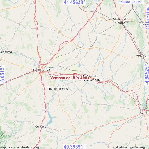
Ventosa del Río Almar GPS coordinates[2]
40° 55' 38.208" North, 5° 20' 54.168" West
| Map corner | latitude | longitude |
|---|---|---|
| Upper-left | 41.45638°, | -6.0515° |
| Center: | 40.92728°, | -5.34838° |
| Lower-right: | 40.39391°, | -4.64525° |
| Map W x H: | 118.1×118.1 km | = 73.4×73.4mi |
| max Lat: | 43.74134° ⇑53.3% North |
| Ventosa del Río Almar: | 40.92728° |
| min Lat: | ⇓46.7% South 27.64134° |
| min Long | Ventosa del Rí | max Long |
| -18.00367° | -5.34838° | 4.2899° |
| W 23.1%⇐ | ⇒76.9% E |
Elevation
Elevation of Ventosa del Río Almar is 856 m = 2808 ft, and this is 258 m = 846 ft above average elevation for this country.
| Max E: |
1682 m = 5518 ft | 24.5% |
| Ventosa del Río Almar | 856 m 2808 ft | |
| Avg. | 598 m = 1962 ft | |
Min E: |
0 m = 0 ft | 75.5% |
See also: Spain elevation on elevation.city.
Geographical zone
Ventosa del Río Almar is located in North temperate zone (between Tropic of Cancer and the Arctic Circle). Distance of this Northern Tropic circle is 1944.8 km =1208.4 mi to South.| Distance of | km | miles | from Ventosa del Río Almar |
|---|---|---|---|
| North Pole | 5456.4 | 3390.4 | to North |
| Arctic Circle | 2850.5 | 1771.2 | to North |
| Tropic Cancer | 1944.8 | 1208.4 | to South |
| Equator | 4550.7 | 2827.7 | to South |


Nearby cities:
15 places around Ventosa del Río Almar: (largest is in red/bold)
• Alconada
2.2 km =1.4 mi,  214°
214°
• Aldeaseca de la Frontera
12 km =7.5 mi,  82°
82°
• Babilafuente
8.5 km =5.3 mi,  310°
310°
• Coca de Alba
5.6 km =3.5 mi,  194°
194°
• Cordovilla
5.6 km =3.5 mi,  298°
298°
• Encinas de Abajo
10.3 km =6.4 mi,  274°
274°
• Garcihernández
10.4 km =6.5 mi,  224°
224°
• Huerta
11 km =6.8 mi,  294°
294°
• Macotera
11.9 km =7.4 mi,  153°
153°
• Nava de Sotrobal
6.7 km =4.2 mi,  127°
127°
• Peñarandilla
6.2 km =3.9 mi, 217°
• Tordillos
8.3 km =5.2 mi,  182°
182°
• Villar de Gallimazo
5.8 km =3.6 mi,  59°
59°
• Villoruela
9.8 km =6.1 mi,  337°
337°
• Villoría
7.8 km =4.8 mi, 344°
Sources, notices
• [Note1] Compared only with cities in Spain existing in our database
• [Src1] Map data: © OpenStreetMap contributors (CC-BY-SA)
• [Src2] Other city data from geonames.org with taken over terms of usage.
• [Src3] Geographical zone / Annual Mean Temperature by Robert A. Rohde @ Wikipedia
