Zorraquín geodata
Zorraquín (La Rioja) is a seat of a third-order administrative division; located in Spain in Europe/Madrid (GMT+2) time zone. With population of 53 people, there are 6431 cities with bigger population in this country. Compared to other cities in Spain, 82.6% of cities are located further ↓South; 53.8% of cities are located further ←West and 76.6% of cities have lower elevation than Zorraquín. Note1


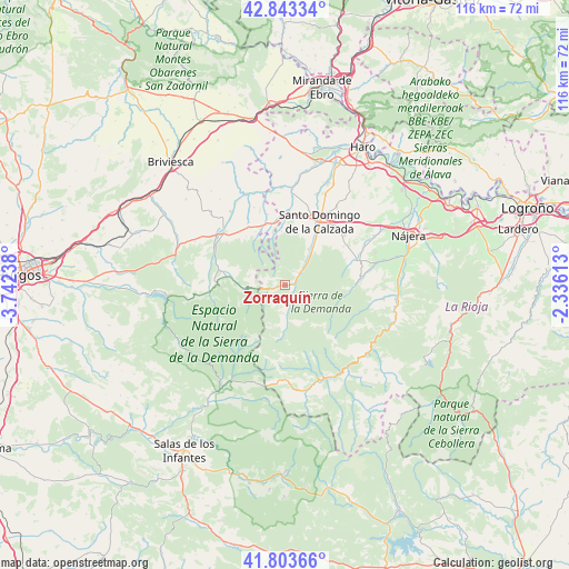
Zorraquín GPS coordinates[2]
42° 19' 32.34" North, 3° 2' 21.3" West
| Map corner | latitude | longitude |
|---|---|---|
| Upper-left | 42.84334°, | -3.74238° |
| Center: | 42.32565°, | -3.03925° |
| Lower-right: | 41.80366°, | -2.33613° |
| Map W x H: | 115.6×115.6 km | = 71.8×71.8mi |
| max Lat: | 43.74134° ⇑17.4% North |
| Zorraquín: | 42.32565° |
| min Lat: | ⇓82.6% South 27.64134° |
| min Long | Zorraquín | max Long |
| -18.00367° | -3.03925° | 4.2899° |
| W 53.8%⇐ | ⇒46.2% E |
Elevation
Elevation of Zorraquín is 866 m = 2841 ft, and this is 268 m = 879 ft above average elevation for this country.
| Max E: |
1682 m = 5518 ft | 23.4% |
| Zorraquín | 866 m 2841 ft | |
| Avg. | 598 m = 1962 ft | |
Min E: |
0 m = 0 ft | 76.6% |
See also: Spain elevation on elevation.city.
Geographical zone
Zorraquín is located in North temperate zone (between Tropic of Cancer and the Arctic Circle). Distance of this Northern Tropic circle is 2100.3 km =1305.1 mi to South.| Distance of | km | miles | from Zorraquín |
|---|---|---|---|
| North Pole | 5300.9 | 3293.8 | to North |
| Arctic Circle | 2695 | 1674.6 | to North |
| Tropic Cancer | 2100.3 | 1305.1 | to South |
| Equator | 4706.2 | 2924.3 | to South |


Nearby cities:
15 places around Zorraquín: (largest is in red/bold)
• Bascuñana
11.6 km =7.2 mi,  342°
342°
• Castildelgado
13 km =8.1 mi, 343°
• Corporales
12.4 km =7.7 mi,  16°
16°
• Ezcaray
2.2 km =1.4 mi,  90°
90°
• Fresneda de la Sierra Tirón
8 km =5 mi,  261°
261°
• Fresneña
12.5 km =7.8 mi,  321°
321°
• Ojacastro
3.7 km =2.3 mi,  49°
49°
• Pazuengos
9.4 km =5.8 mi,  95°
95°
• Redecilla del Camino
12.7 km =7.9 mi,  350°
350°
• San Vicente del Valle
10.2 km =6.3 mi,  277°
277°
• Santurdejo
9 km =5.6 mi, 50°
• Valgañón
2.5 km =1.6 mi,  249°
249°
• Villagalijo
12.8 km =8 mi, 281°
• Villarta-Quintana
11.6 km =7.2 mi,  356°
356°
• Viloria de Rioja
12.2 km =7.6 mi, 335°
Sources, notices
• [Note1] Compared only with cities in Spain existing in our database
• [Src1] Map data: © OpenStreetMap contributors (CC-BY-SA)
• [Src2] Other city data from geonames.org with taken over terms of usage.
• [Src3] Geographical zone / Annual Mean Temperature by Robert A. Rohde @ Wikipedia
