Villadoz geodata
Villadoz (Aragon) is a seat of a third-order administrative division; located in Spain in Europe/Madrid (GMT+2) time zone. With population of 95 people, there are 6001 cities with bigger population in this country. Compared to other cities in Spain, 52.3% of cities are located further ↓South; 74.8% of cities are located further ←West and 79.5% of cities have lower elevation than Villadoz. Note1


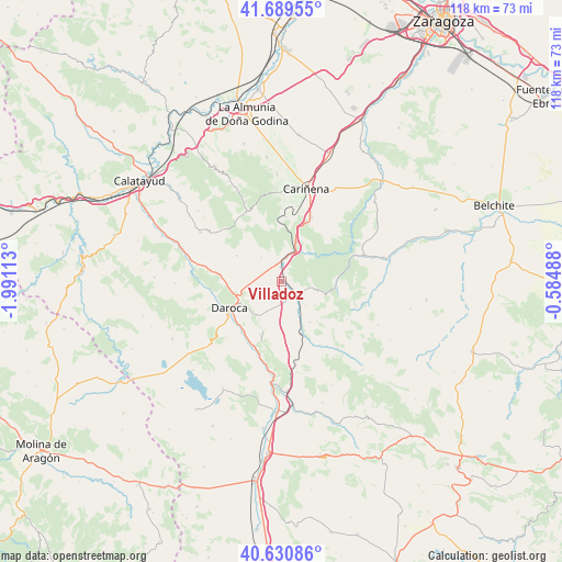
Villadoz GPS coordinates[2]
41° 9' 44.424" North, 1° 17' 16.8" West
| Map corner | latitude | longitude |
|---|---|---|
| Upper-left | 41.68955°, | -1.99113° |
| Center: | 41.16234°, | -1.288° |
| Lower-right: | 40.63086°, | -0.58488° |
| Map W x H: | 117.7×117.7 km | = 73.1×73.1mi |
| max Lat: | 43.74134° ⇑47.7% North |
| Villadoz: | 41.16234° |
| min Lat: | ⇓52.3% South 27.64134° |
| min Long | Villadoz | max Long |
| -18.00367° | -1.288° | 4.2899° |
| W 74.8%⇐ | ⇒25.2% E |
Elevation
Elevation of Villadoz is 893 m = 2930 ft, and this is 295 m = 968 ft above average elevation for this country.
| Max E: |
1682 m = 5518 ft | 20.5% |
| Villadoz | 893 m 2930 ft | |
| Avg. | 598 m = 1962 ft | |
Min E: |
0 m = 0 ft | 79.5% |
See also: Spain elevation on elevation.city.
Geographical zone
Villadoz is located in North temperate zone (between Tropic of Cancer and the Arctic Circle). Distance of this Northern Tropic circle is 1970.9 km =1224.7 mi to South.| Distance of | km | miles | from Villadoz |
|---|---|---|---|
| North Pole | 5430.2 | 3374.2 | to North |
| Arctic Circle | 2824.4 | 1755 | to North |
| Tropic Cancer | 1970.9 | 1224.7 | to South |
| Equator | 4576.8 | 2843.9 | to South |


Nearby cities:
15 places around Villadoz: (largest is in red/bold)
• Badules
3.9 km =2.4 mi,  132°
132°
• Cerveruela
8.5 km =5.3 mi,  45°
45°
• Cucalón
10.5 km =6.5 mi,  144°
144°
• Fombuena
8.2 km =5.1 mi,  104°
104°
• Langa del Castillo
10.8 km =6.7 mi,  300°
300°
• Lanzuela
9.9 km =6.2 mi, 136°
• Lechón
8.5 km =5.3 mi,  178°
178°
• Mainar
3.6 km =2.2 mi,  339°
339°
• Nombrevilla
8.5 km =5.3 mi,  224°
224°
• Retascón
8.3 km =5.2 mi,  255°
255°
• Romanos
4.1 km =2.5 mi,  164°
164°
• Torralbilla
6.8 km =4.2 mi,  321°
321°
• Villahermosa del Campo
6.8 km =4.2 mi,  149°
149°
• Villarreal de Huerva
3.1 km =1.9 mi,  357°
357°
• Villarroya del Campo
3.7 km =2.3 mi,  234°
234°
Sources, notices
• [Note1] Compared only with cities in Spain existing in our database
• [Src1] Map data: © OpenStreetMap contributors (CC-BY-SA)
• [Src2] Other city data from geonames.org with taken over terms of usage.
• [Src3] Geographical zone / Annual Mean Temperature by Robert A. Rohde @ Wikipedia
