Torralbilla geodata
Torralbilla (Aragon) is a seat of a third-order administrative division; located in Spain in Europe/Madrid (GMT+2) time zone. With population of 70 people, there are 6241 cities with bigger population in this country. Compared to other cities in Spain, 53.4% of cities are located further ↓South; 74.4% of cities are located further ←West and 78.9% of cities have lower elevation than Torralbilla. Note1


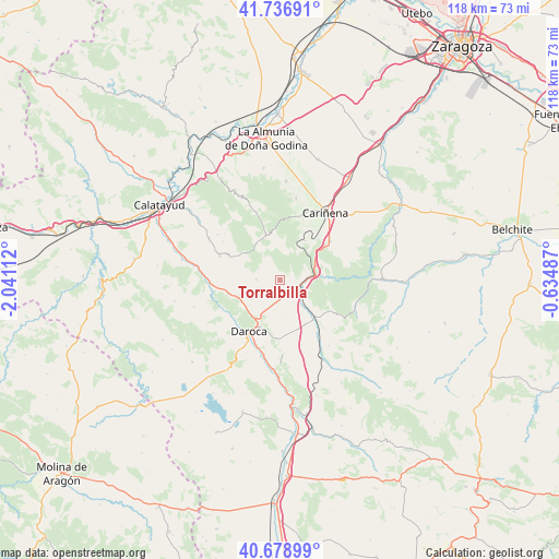
Torralbilla GPS coordinates[2]
41° 12' 36.324" North, 1° 20' 16.8" West
| Map corner | latitude | longitude |
|---|---|---|
| Upper-left | 41.73691°, | -2.04112° |
| Center: | 41.21009°, | -1.338° |
| Lower-right: | 40.67899°, | -0.63487° |
| Map W x H: | 117.6×117.6 km | = 73.1×73.1mi |
| max Lat: | 43.74134° ⇑46.6% North |
| Torralbilla: | 41.21009° |
| min Lat: | ⇓53.4% South 27.64134° |
| min Long | Torralbilla | max Long |
| -18.00367° | -1.338° | 4.2899° |
| W 74.4%⇐ | ⇒25.6% E |
Elevation
Elevation of Torralbilla is 888 m = 2913 ft, and this is 290 m = 951 ft above average elevation for this country.
| Max E: |
1682 m = 5518 ft | 21.1% |
| Torralbilla | 888 m 2913 ft | |
| Avg. | 598 m = 1962 ft | |
Min E: |
0 m = 0 ft | 78.9% |
See also: Spain elevation on elevation.city.
Geographical zone
Torralbilla is located in North temperate zone (between Tropic of Cancer and the Arctic Circle). Distance of this Northern Tropic circle is 1976.2 km =1228 mi to South.| Distance of | km | miles | from Torralbilla |
|---|---|---|---|
| North Pole | 5424.9 | 3370.9 | to North |
| Arctic Circle | 2819 | 1751.6 | to North |
| Tropic Cancer | 1976.2 | 1228 | to South |
| Equator | 4582.1 | 2847.2 | to South |


Nearby cities:
15 places around Torralbilla: (largest is in red/bold)
• Badules
10.6 km =6.6 mi,  138°
138°
• Cerveruela
10.3 km =6.4 mi,  86°
86°
• Codos
9.7 km =6 mi,  341°
341°
• Daroca
12.4 km =7.7 mi,  211°
211°
• Encinacorba
9.9 km =6.2 mi,  32°
32°
• Langa del Castillo
5.1 km =3.2 mi,  272°
272°
• Mainar
3.5 km =2.2 mi,  123°
123°
• Manchones
12.7 km =7.9 mi,  238°
238°
• Nombrevilla
11.6 km =7.2 mi,  188°
188°
• Paniza
13.3 km =8.3 mi,  51°
51°
• Retascón
8.3 km =5.2 mi, 207°
• Romanos
10.7 km =6.6 mi,  150°
150°
• Villadoz
6.8 km =4.2 mi, 141°
• Villarreal de Huerva
4.6 km =2.9 mi, 118°
• Villarroya del Campo
7.5 km =4.7 mi,  171°
171°
Sources, notices
• [Note1] Compared only with cities in Spain existing in our database
• [Src1] Map data: © OpenStreetMap contributors (CC-BY-SA)
• [Src2] Other city data from geonames.org with taken over terms of usage.
• [Src3] Geographical zone / Annual Mean Temperature by Robert A. Rohde @ Wikipedia
