Romanos geodata
Romanos (Aragon) is a seat of a third-order administrative division; located in Spain in Europe/Madrid (GMT+2) time zone. With population of 114 people, there are 5769 cities with bigger population in this country. Compared to other cities in Spain, 51.6% of cities are located further ↓South; 75% of cities are located further ←West and 84.7% of cities have lower elevation than Romanos. Note1


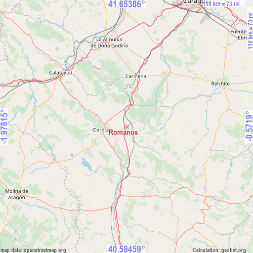
Romanos GPS coordinates[2]
41° 7' 34.896" North, 1° 16' 30.072" West
| Map corner | latitude | longitude |
|---|---|---|
| Upper-left | 41.65386°, | -1.97815° |
| Center: | 41.12636°, | -1.27502° |
| Lower-right: | 40.59459°, | -0.5719° |
| Map W x H: | 117.8×117.8 km | = 73.2×73.2mi |
| max Lat: | 43.74134° ⇑48.4% North |
| Romanos: | 41.12636° |
| min Lat: | ⇓51.6% South 27.64134° |
| min Long | Romanos | max Long |
| -18.00367° | -1.27502° | 4.2899° |
| W 75%⇐ | ⇒25% E |
Elevation
Elevation of Romanos is 948 m = 3110 ft, and this is 350 m = 1148 ft above average elevation for this country.
| Max E: |
1682 m = 5518 ft | 15.3% |
| Romanos | 948 m 3110 ft | |
| Avg. | 598 m = 1962 ft | |
Min E: |
0 m = 0 ft | 84.7% |
See also: Spain elevation on elevation.city.
Geographical zone
Romanos is located in North temperate zone (between Tropic of Cancer and the Arctic Circle). Distance of this Northern Tropic circle is 1966.9 km =1222.2 mi to South.| Distance of | km | miles | from Romanos |
|---|---|---|---|
| North Pole | 5434.2 | 3376.7 | to North |
| Arctic Circle | 2828.4 | 1757.5 | to North |
| Tropic Cancer | 1966.9 | 1222.2 | to South |
| Equator | 4572.8 | 2841.4 | to South |


Nearby cities:
15 places around Romanos: (largest is in red/bold)
• Anento
8 km =5 mi,  217°
217°
• Badules
2.3 km =1.4 mi,  51°
51°
• Cucalón
6.7 km =4.2 mi,  131°
131°
• Ferreruela de Huerva
7.8 km =4.8 mi,  153°
153°
• Fombuena
7.2 km =4.5 mi,  73°
73°
• Lanzuela
6.5 km =4 mi,  118°
118°
• Lechón
4.5 km =2.8 mi,  190°
190°
• Mainar
7.7 km =4.8 mi,  342°
342°
• Nombrevilla
7.4 km =4.6 mi,  253°
253°
• Retascón
9.3 km =5.8 mi,  281°
281°
• Torralbilla
10.7 km =6.6 mi,  330°
330°
• Villadoz
4.1 km =2.5 mi, 344°
• Villahermosa del Campo
3 km =1.9 mi, 128°
• Villarreal de Huerva
7.2 km =4.5 mi,  350°
350°
• Villarroya del Campo
4.5 km =2.8 mi,  294°
294°
Sources, notices
• [Note1] Compared only with cities in Spain existing in our database
• [Src1] Map data: © OpenStreetMap contributors (CC-BY-SA)
• [Src2] Other city data from geonames.org with taken over terms of usage.
• [Src3] Geographical zone / Annual Mean Temperature by Robert A. Rohde @ Wikipedia
