Nombrevilla geodata
Nombrevilla (Aragon) is a seat of a third-order administrative division; located in Spain in Europe/Madrid (GMT+2) time zone. With population of 47 people, there are 6495 cities with bigger population in this country. Compared to other cities in Spain, 51.1% of cities are located further ↓South; 74.2% of cities are located further ←West and 82.2% of cities have lower elevation than Nombrevilla. Note1


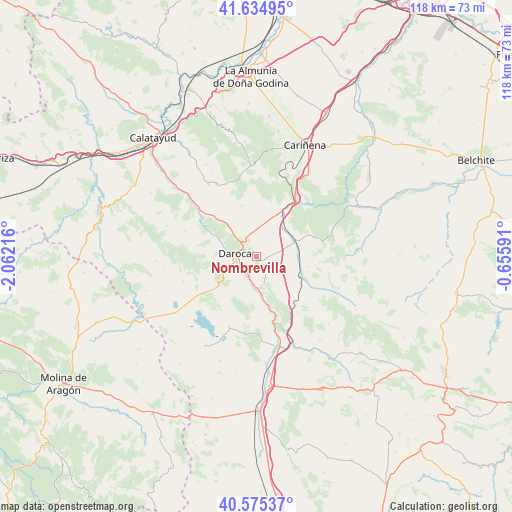
Nombrevilla GPS coordinates[2]
41° 6' 26.28" North, 1° 21' 32.544" West
| Map corner | latitude | longitude |
|---|---|---|
| Upper-left | 41.63495°, | -2.06216° |
| Center: | 41.1073°, | -1.35904° |
| Lower-right: | 40.57537°, | -0.65591° |
| Map W x H: | 117.8×117.8 km | = 73.2×73.2mi |
| max Lat: | 43.74134° ⇑48.9% North |
| Nombrevilla: | 41.1073° |
| min Lat: | ⇓51.1% South 27.64134° |
| min Long | Nombrevilla | max Long |
| -18.00367° | -1.35904° | 4.2899° |
| W 74.2%⇐ | ⇒25.8% E |
Elevation
Elevation of Nombrevilla is 919 m = 3015 ft, and this is 321 m = 1053 ft above average elevation for this country.
| Max E: |
1682 m = 5518 ft | 17.8% |
| Nombrevilla | 919 m 3015 ft | |
| Avg. | 598 m = 1962 ft | |
Min E: |
0 m = 0 ft | 82.2% |
See also: Spain elevation on elevation.city.
Geographical zone
Nombrevilla is located in North temperate zone (between Tropic of Cancer and the Arctic Circle). Distance of this Northern Tropic circle is 1964.8 km =1220.9 mi to South.| Distance of | km | miles | from Nombrevilla |
|---|---|---|---|
| North Pole | 5436.4 | 3378 | to North |
| Arctic Circle | 2830.5 | 1758.8 | to North |
| Tropic Cancer | 1964.8 | 1220.9 | to South |
| Equator | 4570.7 | 2840.1 | to South |


Nearby cities:
15 places around Nombrevilla: (largest is in red/bold)
• Anento
4.7 km =2.9 mi,  153°
153°
• Badules
9.5 km =5.9 mi,  68°
68°
• Balconchán
8.7 km =5.4 mi,  255°
255°
• Báguena
7.3 km =4.5 mi,  179°
179°
• Daroca
4.8 km =3 mi,  280°
280°
• Lechón
6.6 km =4.1 mi,  110°
110°
• Retascón
4.5 km =2.8 mi,  332°
332°
• Romanos
7.4 km =4.6 mi, 73°
• San Martín del Río
5.1 km =3.2 mi,  207°
207°
• Val de San Martín
9.4 km =5.8 mi,  234°
234°
• Valdehorna
6.6 km =4.1 mi, 234°
• Villadoz
8.5 km =5.3 mi,  44°
44°
• Villahermosa del Campo
9.4 km =5.8 mi,  88°
88°
• Villanueva de Jiloca
4.3 km =2.7 mi,  216°
216°
• Villarroya del Campo
4.9 km =3 mi, 36°
Sources, notices
• [Note1] Compared only with cities in Spain existing in our database
• [Src1] Map data: © OpenStreetMap contributors (CC-BY-SA)
• [Src2] Other city data from geonames.org with taken over terms of usage.
• [Src3] Geographical zone / Annual Mean Temperature by Robert A. Rohde @ Wikipedia
