Campazas geodata
Campazas (Castille and León) is a seat of a third-order administrative division; located in Spain in Europe/Madrid (GMT+2) time zone. With population of 151 people, there are 5422 cities with bigger population in this country. Compared to other cities in Spain, 77.7% of cities are located further ↓South; 78.6% of cities are located further →East and 64.6% of cities have lower elevation than Campazas. Note1


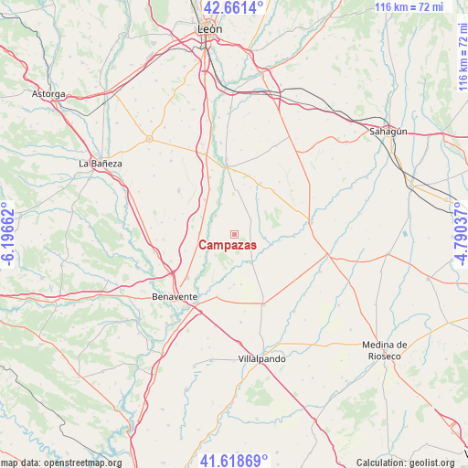
Campazas GPS coordinates[2]
42° 8' 31.884" North, 5° 29' 36.564" West
| Map corner | latitude | longitude |
|---|---|---|
| Upper-left | 42.6614°, | -6.19662° |
| Center: | 42.14219°, | -5.49349° |
| Lower-right: | 41.61869°, | -4.79037° |
| Map W x H: | 115.9×115.9 km | = 72×72mi |
| max Lat: | 43.74134° ⇑22.3% North |
| Campazas: | 42.14219° |
| min Lat: | ⇓77.7% South 27.64134° |
| min Long | Campazas | max Long |
| -18.00367° | -5.49349° | 4.2899° |
| W 21.4%⇐ | ⇒78.6% E |
Elevation
Elevation of Campazas is 775 m = 2543 ft, and this is 177 m = 581 ft above average elevation for this country.
| Max E: |
1682 m = 5518 ft | 35.4% |
| Campazas | 775 m 2543 ft | |
| Avg. | 598 m = 1962 ft | |
Min E: |
0 m = 0 ft | 64.6% |
See also: Spain elevation on elevation.city.
Geographical zone
Campazas is located in North temperate zone (between Tropic of Cancer and the Arctic Circle). Distance of this Northern Tropic circle is 2079.9 km =1292.4 mi to South.| Distance of | km | miles | from Campazas |
|---|---|---|---|
| North Pole | 5321.3 | 3306.5 | to North |
| Arctic Circle | 2715.4 | 1687.3 | to North |
| Tropic Cancer | 2079.9 | 1292.4 | to South |
| Equator | 4685.8 | 2911.6 | to South |


Nearby cities:
15 places around Campazas: (largest is in red/bold)
• Algadefe
11.4 km =7.1 mi,  318°
318°
• Castilfalé
10.5 km =6.5 mi,  34°
34°
• Castrobol
14.8 km =9.2 mi,  92°
92°
• Cimanes de la Vega
9.1 km =5.7 mi,  251°
251°
• Fuentes de Carbajal
5.6 km =3.5 mi,  44°
44°
• Gordoncillo
7.6 km =4.7 mi,  95°
95°
• Matilla de Arzón
12.9 km =8 mi, 251°
• Toral de los Guzmanes
12.7 km =7.9 mi,  331°
331°
• Valdemora
8 km =5 mi, 42°
• Valderas
8.2 km =5.1 mi,  149°
149°
• Valdescorriel
13.4 km =8.3 mi,  185°
185°
• Villabraz
12.3 km =7.6 mi,  18°
18°
• Villademor de la Vega
15.4 km =9.6 mi,  336°
336°
• Villamandos
9.3 km =5.8 mi,  297°
297°
• Villaquejida
8.5 km =5.3 mi,  272°
272°
Sources, notices
• [Note1] Compared only with cities in Spain existing in our database
• [Src1] Map data: © OpenStreetMap contributors (CC-BY-SA)
• [Src2] Other city data from geonames.org with taken over terms of usage.
• [Src3] Geographical zone / Annual Mean Temperature by Robert A. Rohde @ Wikipedia
