Viguera geodata
Viguera (La Rioja) is a seat of a third-order administrative division; located in Spain in Europe/Madrid (GMT+2) time zone. With population of 416 people, there are 4087 cities with bigger population in this country. Compared to other cities in Spain, 82% of cities are located further ↓South; 60.5% of cities are located further ←West and 54.6% of cities have lower elevation than Viguera. Note1


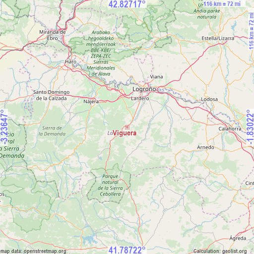
Viguera GPS coordinates[2]
42° 18' 33.624" North, 2° 32' 0.024" West
| Map corner | latitude | longitude |
|---|---|---|
| Upper-left | 42.82717°, | -3.23647° |
| Center: | 42.30934°, | -2.53334° |
| Lower-right: | 41.78722°, | -1.83022° |
| Map W x H: | 115.6×115.6 km | = 71.8×71.8mi |
| max Lat: | 43.74134° ⇑18% North |
| Viguera: | 42.30934° |
| min Lat: | ⇓82% South 27.64134° |
| min Long | Viguera | max Long |
| -18.00367° | -2.53334° | 4.2899° |
| W 60.5%⇐ | ⇒39.5% E |
Elevation
Elevation of Viguera is 706 m = 2316 ft, and this is 108 m = 354 ft above average elevation for this country.
| Max E: |
1682 m = 5518 ft | 45.4% |
| Viguera | 706 m 2316 ft | |
| Avg. | 598 m = 1962 ft | |
Min E: |
0 m = 0 ft | 54.6% |
See also: Spain elevation on elevation.city.
Geographical zone
Viguera is located in North temperate zone (between Tropic of Cancer and the Arctic Circle). Distance of this Northern Tropic circle is 2098.4 km =1303.9 mi to South.| Distance of | km | miles | from Viguera |
|---|---|---|---|
| North Pole | 5302.7 | 3294.9 | to North |
| Arctic Circle | 2696.8 | 1675.7 | to North |
| Tropic Cancer | 2098.4 | 1303.9 | to South |
| Equator | 4704.4 | 2923.2 | to South |


Nearby cities:
15 places around Viguera: (largest is in red/bold)
• Albelda de Iregua
7.4 km =4.6 mi,  42°
42°
• Clavijo
9.8 km =6.1 mi,  63°
63°
• Daroca de Rioja
7.9 km =4.9 mi,  329°
329°
• Entrena
8.7 km =5.4 mi,  1°
1°
• Medrano
8.4 km =5.2 mi,  348°
348°
• Muro en Cameros
9.4 km =5.8 mi,  178°
178°
• Nalda
4.7 km =2.9 mi,  53°
53°
• Nestares
8.4 km =5.2 mi,  238°
238°
• San Román de Cameros
9.8 km =6.1 mi,  150°
150°
• Sojuela
6.8 km =4.2 mi, 351°
• Sorzano
3.8 km =2.4 mi,  5°
5°
• Soto en Cameros
9.2 km =5.7 mi,  106°
106°
• Terroba
9.3 km =5.8 mi,  127°
127°
• Torre en Cameros
7.7 km =4.8 mi,  170°
170°
• Torrecilla en Cameros
10 km =6.2 mi,  233°
233°
Sources, notices
• [Note1] Compared only with cities in Spain existing in our database
• [Src1] Map data: © OpenStreetMap contributors (CC-BY-SA)
• [Src2] Other city data from geonames.org with taken over terms of usage.
• [Src3] Geographical zone / Annual Mean Temperature by Robert A. Rohde @ Wikipedia
