Nalda geodata
Nalda (La Rioja) is a seat of a third-order administrative division; located in Spain in Europe/Madrid (GMT+2) time zone. With population of 960 people, there are 3005 cities with bigger population in this country. Compared to other cities in Spain, 82.9% of cities are located further ↓South; 61.1% of cities are located further ←West and 52.3% of cities have higher elevation than Nalda. Note1


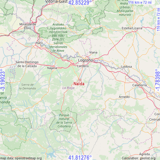
Nalda GPS coordinates[2]
42° 20' 4.812" North, 2° 29' 13.56" West
| Map corner | latitude | longitude |
|---|---|---|
| Upper-left | 42.85229°, | -3.19023° |
| Center: | 42.33467°, | -2.4871° |
| Lower-right: | 41.81276°, | -1.78398° |
| Map W x H: | 115.6×115.6 km | = 71.8×71.8mi |
| max Lat: | 43.74134° ⇑17.1% North |
| Nalda: | 42.33467° |
| min Lat: | ⇓82.9% South 27.64134° |
| min Long | Nalda | max Long |
| -18.00367° | -2.4871° | 4.2899° |
| W 61.1%⇐ | ⇒38.9% E |
Elevation
Elevation of Nalda is 633 m = 2077 ft, and this is 35 m = 115 ft above average elevation for this country.
| Max E: |
1682 m = 5518 ft | 52.3% |
| Nalda | 633 m 2077 ft | |
| Avg. | 598 m = 1962 ft | |
Min E: |
0 m = 0 ft | 47.7% |
See also: Spain elevation on elevation.city.
Geographical zone
Nalda is located in North temperate zone (between Tropic of Cancer and the Arctic Circle). Distance of this Northern Tropic circle is 2101.3 km =1305.7 mi to South.| Distance of | km | miles | from Nalda |
|---|---|---|---|
| North Pole | 5299.9 | 3293.2 | to North |
| Arctic Circle | 2694 | 1674 | to North |
| Tropic Cancer | 2101.3 | 1305.7 | to South |
| Equator | 4707.2 | 2924.9 | to South |


Nearby cities:
15 places around Nalda: (largest is in red/bold)
• Albelda de Iregua
2.9 km =1.8 mi,  24°
24°
• Alberite
9 km =5.6 mi,  26°
26°
• Clavijo
5.2 km =3.2 mi,  72°
72°
• Daroca de Rioja
8.8 km =5.5 mi,  297°
297°
• Entrena
6.9 km =4.3 mi,  328°
328°
• Hornos de Moncalvillo
10.3 km =6.4 mi,  308°
308°
• Lardero
10.5 km =6.5 mi,  11°
11°
• Leza de Río Leza
6.7 km =4.2 mi,  94°
94°
• Medrano
7.7 km =4.8 mi, 314°
• Ribafrecha
8.3 km =5.2 mi, 73°
• Sojuela
6.2 km =3.9 mi, 309°
• Sorzano
3.5 km =2.2 mi,  285°
285°
• Soto en Cameros
7.4 km =4.6 mi,  137°
137°
• Terroba
9.2 km =5.7 mi,  157°
157°
• Viguera
4.7 km =2.9 mi,  233°
233°
Sources, notices
• [Note1] Compared only with cities in Spain existing in our database
• [Src1] Map data: © OpenStreetMap contributors (CC-BY-SA)
• [Src2] Other city data from geonames.org with taken over terms of usage.
• [Src3] Geographical zone / Annual Mean Temperature by Robert A. Rohde @ Wikipedia
