Verdú geodata
Verdú (Catalonia) is a seat of a third-order administrative division; located in Spain in Europe/Madrid (GMT+2) time zone. With population of 1,057 people, there are 2871 cities with bigger population in this country. Compared to other cities in Spain, 63.7% of cities are located further ↓South; 90.9% of cities are located further ←West and 66.6% of cities have higher elevation than Verdú. Note1


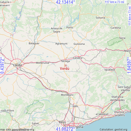
Verdú GPS coordinates[2]
41° 36' 38.052" North, 1° 8' 34.224" East
| Map corner | latitude | longitude |
|---|---|---|
| Upper-left | 42.13414°, | 0.43972° |
| Center: | 41.61057°, | 1.14284° |
| Lower-right: | 41.08272°, | 1.84597° |
| Map W x H: | 116.9×116.9 km | = 72.6×72.6mi |
| max Lat: | 43.74134° ⇑36.3% North |
| Verdú: | 41.61057° |
| min Lat: | ⇓63.7% South 27.64134° |
| min Long | Verdú | max Long |
| -18.00367° | 1.14284° | 4.2899° |
| W 90.9%⇐ | ⇒9.1% E |
Elevation
Elevation of Verdú is 439 m = 1440 ft, and this is 159 m = 522 ft below average elevation for this country.
| Max E: |
1682 m = 5518 ft | 66.6% |
| Avg. | 598 m = 1962 ft | |
| Verdú | 439 m = 1440 ft | |
Min E: |
0 m = 0 ft | 33.4% |
See also: Spain elevation on elevation.city.
Geographical zone
Verdú is located in North temperate zone (between Tropic of Cancer and the Arctic Circle). Distance of this Northern Tropic circle is 2020.7 km =1255.6 mi to South.| Distance of | km | miles | from Verdú |
|---|---|---|---|
| North Pole | 5380.4 | 3343.2 | to North |
| Arctic Circle | 2774.5 | 1724 | to North |
| Tropic Cancer | 2020.7 | 1255.6 | to South |
| Equator | 4626.7 | 2874.9 | to South |


Nearby cities:
15 places around Verdú: (largest is in red/bold)
• Anglesola
7.1 km =4.4 mi,  315°
315°
• Barbens
12.9 km =8 mi,  305°
305°
• Belianes
11.9 km =7.4 mi,  242°
242°
• Bellpuig
11.1 km =6.9 mi,  278°
278°
• Castellnou de Seana
14.9 km =9.3 mi,  286°
286°
• Cervera
12.6 km =7.8 mi,  58°
58°
• Ciutadilla
5.5 km =3.4 mi,  183°
183°
• Guimerà
6.2 km =3.9 mi,  145°
145°
• Ivars d'Urgell
15.1 km =9.4 mi,  300°
300°
• Nalec
7.1 km =4.4 mi,  197°
197°
• Tornabous
12.5 km =7.8 mi, 323°
• Tàrrega
4.1 km =2.5 mi,  356°
356°
• Vallbona de les Monges
10.4 km =6.5 mi,  205°
205°
• Vallfogona de Riucorb
9.5 km =5.9 mi,  124°
124°
• Vilanova de Bellpuig
14.8 km =9.2 mi,  271°
271°
Sources, notices
• [Note1] Compared only with cities in Spain existing in our database
• [Src1] Map data: © OpenStreetMap contributors (CC-BY-SA)
• [Src2] Other city data from geonames.org with taken over terms of usage.
• [Src3] Geographical zone / Annual Mean Temperature by Robert A. Rohde @ Wikipedia
