Valverde de Alcalá geodata
Valverde de Alcalá (Madrid) is a seat of a third-order administrative division; located in Spain in Europe/Madrid (GMT+2) time zone. With population of 346 people, there are 4324 cities with bigger population in this country. Compared to other cities in Spain, 63.6% of cities are located further ↑North; 50.5% of cities are located further ←West and 61.5% of cities have lower elevation than Valverde de Alcalá. Note1
Administrative division(s):
- Level 1: Madrid
- Level 2: Provincia de Madrid
- Level 3: Valverde de Alcalá


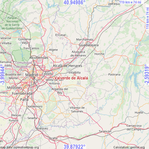
Valverde de Alcalá GPS coordinates[2]
40° 25' 0.012" North, 3° 17' 46.716" West
| Map corner | latitude | longitude |
|---|---|---|
| Upper-left | 40.94986°, | -3.99944° |
| Center: | 40.41667°, | -3.29631° |
| Lower-right: | 39.87922°, | -2.59319° |
| Map W x H: | 119×119 km | = 73.9×73.9mi |
| max Lat: | 43.74134° ⇑63.6% North |
| Valverde de Alcalá: | 40.41667° |
| min Lat: | ⇓36.4% South 27.64134° |
| min Long | Valverde de Alc | max Long |
| -18.00367° | -3.29631° | 4.2899° |
| W 50.5%⇐ | ⇒49.5% E |
Elevation
Elevation of Valverde de Alcalá is 754 m = 2474 ft, and this is 156 m = 512 ft above average elevation for this country.
| Max E: |
1682 m = 5518 ft | 38.5% |
| Valverde de Alcalá | 754 m 2474 ft | |
| Avg. | 598 m = 1962 ft | |
Min E: |
0 m = 0 ft | 61.5% |
See also: Spain elevation on elevation.city.
Geographical zone
Valverde de Alcalá is located in North temperate zone (between Tropic of Cancer and the Arctic Circle). Distance of this Northern Tropic circle is 1888 km =1173.1 mi to South.| Distance of | km | miles | from Valverde de Alcalá |
|---|---|---|---|
| North Pole | 5513.1 | 3425.7 | to North |
| Arctic Circle | 2907.3 | 1806.5 | to North |
| Tropic Cancer | 1888 | 1173.1 | to South |
| Equator | 4493.9 | 2792.4 | to South |


Nearby cities:
15 places around Valverde de Alcalá: (largest is in red/bold)
• Alcalá de Henares
9 km =5.6 mi,  323°
323°
• Anchuelo
5.9 km =3.7 mi,  23°
23°
• Campo Real
11.8 km =7.3 mi,  218°
218°
• Corpa
3.2 km =2 mi,  76°
76°
• Loeches
10.7 km =6.6 mi,  249°
249°
• Los Santos de la Humosa
9.9 km =6.2 mi, 21°
• Nuevo Baztán
7.2 km =4.5 mi,  139°
139°
• Pezuela de las Torres
10.4 km =6.5 mi,  90°
90°
• Pioz
11.6 km =7.2 mi,  64°
64°
• Pozo de Guadalajara
13.1 km =8.1 mi,  48°
48°
• Pozuelo del Rey
6 km =3.7 mi,  196°
196°
• Santorcaz
8 km =5 mi,  40°
40°
• Torres de la Alameda
5.4 km =3.4 mi, 253°
• Villalbilla
1.5 km =0.9 mi,  351°
351°
• Villar del Olmo
10.5 km =6.5 mi,  149°
149°
Sources, notices
• [Note1] Compared only with cities in Spain existing in our database
• [Src1] Map data: © OpenStreetMap contributors (CC-BY-SA)
• [Src2] Other city data from geonames.org with taken over terms of usage.
• [Src3] Geographical zone / Annual Mean Temperature by Robert A. Rohde @ Wikipedia
