Pozuelo del Rey geodata
Pozuelo del Rey (Madrid) is a seat of a third-order administrative division; located in Spain in Europe/Madrid (GMT+2) time zone. With population of 323 people, there are 4413 cities with bigger population in this country. Compared to other cities in Spain, 64.6% of cities are located further ↑North; 50.2% of cities are located further ←West and 69.3% of cities have lower elevation than Pozuelo del Rey. Note1


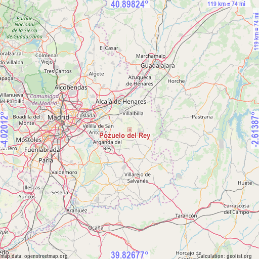
Pozuelo del Rey GPS coordinates[2]
40° 21' 52.668" North, 3° 19' 1.164" West
| Map corner | latitude | longitude |
|---|---|---|
| Upper-left | 40.89824°, | -4.02012° |
| Center: | 40.36463°, | -3.31699° |
| Lower-right: | 39.82677°, | -2.61387° |
| Map W x H: | 119.1×119.1 km | = 74×74mi |
| max Lat: | 43.74134° ⇑64.6% North |
| Pozuelo del Rey: | 40.36463° |
| min Lat: | ⇓35.4% South 27.64134° |
| min Long | Pozuelo del Rey | max Long |
| -18.00367° | -3.31699° | 4.2899° |
| W 50.2%⇐ | ⇒49.8% E |
Elevation
Elevation of Pozuelo del Rey is 808 m = 2651 ft, and this is 210 m = 689 ft above average elevation for this country.
| Max E: |
1682 m = 5518 ft | 30.7% |
| Pozuelo del Rey | 808 m 2651 ft | |
| Avg. | 598 m = 1962 ft | |
Min E: |
0 m = 0 ft | 69.3% |
See also: Spain elevation on elevation.city.
Geographical zone
Pozuelo del Rey is located in North temperate zone (between Tropic of Cancer and the Arctic Circle). Distance of this Northern Tropic circle is 1882.2 km =1169.5 mi to South.| Distance of | km | miles | from Pozuelo del Rey |
|---|---|---|---|
| North Pole | 5518.9 | 3429.3 | to North |
| Arctic Circle | 2913 | 1810.1 | to North |
| Tropic Cancer | 1882.2 | 1169.5 | to South |
| Equator | 4488.1 | 2788.8 | to South |


Nearby cities:
15 places around Pozuelo del Rey: (largest is in red/bold)
• Ambite
12.1 km =7.5 mi,  107°
107°
• Anchuelo
11.9 km =7.4 mi,  20°
20°
• Arganda
12.4 km =7.7 mi,  235°
235°
• Campo Real
6.6 km =4.1 mi, 238°
• Corpa
8.1 km =5 mi,  36°
36°
• Loeches
8.5 km =5.3 mi,  284°
284°
• Nuevo Baztán
6.4 km =4 mi,  87°
87°
• Orusco
13.1 km =8.1 mi,  133°
133°
• Pezuela de las Torres
13.4 km =8.3 mi,  64°
64°
• Tielmes
13.1 km =8.1 mi,  179°
179°
• Torres de la Alameda
5.5 km =3.4 mi,  320°
320°
• Valdilecha
7.8 km =4.8 mi,  170°
170°
• Valverde de Alcalá
6 km =3.7 mi, 16°
• Villalbilla
7.5 km =4.7 mi,  11°
11°
• Villar del Olmo
7.8 km =4.8 mi,  115°
115°
Sources, notices
• [Note1] Compared only with cities in Spain existing in our database
• [Src1] Map data: © OpenStreetMap contributors (CC-BY-SA)
• [Src2] Other city data from geonames.org with taken over terms of usage.
• [Src3] Geographical zone / Annual Mean Temperature by Robert A. Rohde @ Wikipedia
