Loeches geodata
Loeches (Madrid) is a seat of a third-order administrative division; located in Spain in Europe/Madrid (GMT+2) time zone. With population of 4,805 people, there are 1344 cities with bigger population in this country. Compared to other cities in Spain, 64.3% of cities are located further ↑North; 50.9% of cities are located further →East and 51.2% of cities have higher elevation than Loeches. Note1


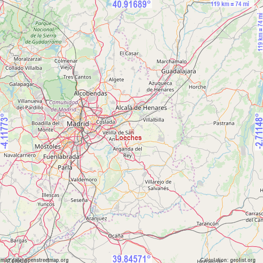
Loeches GPS coordinates[2]
40° 23' 0.348" North, 3° 24' 52.56" West
| Map corner | latitude | longitude |
|---|---|---|
| Upper-left | 40.91689°, | -4.11773° |
| Center: | 40.38343°, | -3.4146° |
| Lower-right: | 39.84571°, | -2.71148° |
| Map W x H: | 119.1×119.1 km | = 74×74mi |
| max Lat: | 43.74134° ⇑64.3% North |
| Loeches: | 40.38343° |
| min Lat: | ⇓35.7% South 27.64134° |
| min Long | Loeches | max Long |
| -18.00367° | -3.4146° | 4.2899° |
| W 49.1%⇐ | ⇒50.9% E |
Elevation
Elevation of Loeches is 646 m = 2119 ft, and this is 48 m = 157 ft above average elevation for this country.
| Max E: |
1682 m = 5518 ft | 51.2% |
| Loeches | 646 m 2119 ft | |
| Avg. | 598 m = 1962 ft | |
Min E: |
0 m = 0 ft | 48.8% |
See also: Spain elevation on elevation.city.
Geographical zone
Loeches is located in North temperate zone (between Tropic of Cancer and the Arctic Circle). Distance of this Northern Tropic circle is 1884.3 km =1170.8 mi to South.| Distance of | km | miles | from Loeches |
|---|---|---|---|
| North Pole | 5516.8 | 3428 | to North |
| Arctic Circle | 2911 | 1808.8 | to North |
| Tropic Cancer | 1884.3 | 1170.8 | to South |
| Equator | 4490.2 | 2790.1 | to South |


Nearby cities:
15 places around Loeches: (largest is in red/bold)
• Alcalá de Henares
11.9 km =7.4 mi,  22°
22°
• Arganda
9.4 km =5.8 mi,  191°
191°
• Campo Real
6.2 km =3.9 mi,  154°
154°
• Corpa
13.8 km =8.6 mi,  71°
71°
• Coslada
13.2 km =8.2 mi,  289°
289°
• Mejorada del Campo
5.8 km =3.6 mi,  280°
280°
• Pozuelo del Rey
8.5 km =5.3 mi,  104°
104°
• Rivas-Vaciamadrid
10.4 km =6.5 mi,  231°
231°
• San Fernando de Henares
11 km =6.8 mi, 294°
• Torrejón de Ardoz
9.3 km =5.8 mi,  329°
329°
• Torres de la Alameda
5.3 km =3.3 mi, 66°
• Valdilecha
13.7 km =8.5 mi,  135°
135°
• Valverde de Alcalá
10.7 km =6.6 mi, 69°
• Velilla de San Antonio
6.3 km =3.9 mi,  251°
251°
• Villalbilla
11.1 km =6.9 mi,  61°
61°
Sources, notices
• [Note1] Compared only with cities in Spain existing in our database
• [Src1] Map data: © OpenStreetMap contributors (CC-BY-SA)
• [Src2] Other city data from geonames.org with taken over terms of usage.
• [Src3] Geographical zone / Annual Mean Temperature by Robert A. Rohde @ Wikipedia
