Corpa geodata
Corpa (Madrid) is a seat of a third-order administrative division; located in Spain in Europe/Madrid (GMT+2) time zone. With population of 547 people, there are 3746 cities with bigger population in this country. Compared to other cities in Spain, 63.5% of cities are located further ↑North; 50.9% of cities are located further ←West and 70% of cities have lower elevation than Corpa. Note1


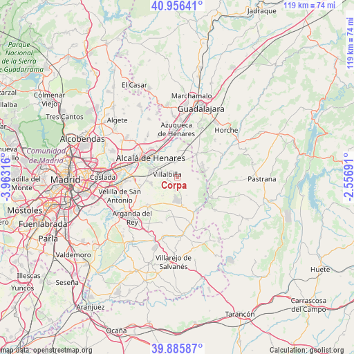
Corpa GPS coordinates[2]
40° 25' 23.772" North, 3° 15' 36.108" West
| Map corner | latitude | longitude |
|---|---|---|
| Upper-left | 40.95641°, | -3.96316° |
| Center: | 40.42327°, | -3.26003° |
| Lower-right: | 39.88587°, | -2.55691° |
| Map W x H: | 119×119 km | = 73.9×73.9mi |
| max Lat: | 43.74134° ⇑63.5% North |
| Corpa: | 40.42327° |
| min Lat: | ⇓36.5% South 27.64134° |
| min Long | Corpa | max Long |
| -18.00367° | -3.26003° | 4.2899° |
| W 50.9%⇐ | ⇒49.1% E |
Elevation
Elevation of Corpa is 814 m = 2671 ft, and this is 216 m = 709 ft above average elevation for this country.
| Max E: |
1682 m = 5518 ft | 30% |
| Corpa | 814 m 2671 ft | |
| Avg. | 598 m = 1962 ft | |
Min E: |
0 m = 0 ft | 70% |
See also: Spain elevation on elevation.city.
Geographical zone
Corpa is located in North temperate zone (between Tropic of Cancer and the Arctic Circle). Distance of this Northern Tropic circle is 1888.7 km =1173.6 mi to South.| Distance of | km | miles | from Corpa |
|---|---|---|---|
| North Pole | 5512.4 | 3425.2 | to North |
| Arctic Circle | 2906.5 | 1806 | to North |
| Tropic Cancer | 1888.7 | 1173.6 | to South |
| Equator | 4494.6 | 2792.8 | to South |


Nearby cities:
15 places around Corpa: (largest is in red/bold)
• Alcalá de Henares
10.7 km =6.6 mi,  307°
307°
• Ambite
12.2 km =7.6 mi,  146°
146°
• Anchuelo
4.7 km =2.9 mi,  351°
351°
• Loranca de Tajuña
12.8 km =8 mi,  79°
79°
• Los Santos de la Humosa
8.5 km =5.3 mi,  3°
3°
• Nuevo Baztán
6.4 km =4 mi,  165°
165°
• Pezuela de las Torres
7.4 km =4.6 mi,  96°
96°
• Pioz
8.6 km =5.3 mi,  60°
60°
• Pozo de Guadalajara
10.4 km =6.5 mi,  39°
39°
• Pozuelo del Rey
8.1 km =5 mi,  216°
216°
• Santorcaz
5.8 km =3.6 mi,  21°
21°
• Torres de la Alameda
8.6 km =5.3 mi,  254°
254°
• Valverde de Alcalá
3.2 km =2 mi,  256°
256°
• Villalbilla
3.4 km =2.1 mi,  283°
283°
• Villar del Olmo
10.1 km =6.3 mi, 167°
Sources, notices
• [Note1] Compared only with cities in Spain existing in our database
• [Src1] Map data: © OpenStreetMap contributors (CC-BY-SA)
• [Src2] Other city data from geonames.org with taken over terms of usage.
• [Src3] Geographical zone / Annual Mean Temperature by Robert A. Rohde @ Wikipedia
