Pioz geodata
Pioz (Castille-La Mancha) is a seat of a third-order administrative division; located in Spain in Europe/Madrid (GMT+2) time zone. With population of 969 people, there are 2989 cities with bigger population in this country. Compared to other cities in Spain, 62.7% of cities are located further ↑North; 51.9% of cities are located further ←West and 76.5% of cities have lower elevation than Pioz. Note1
Administrative division(s):
- Level 1: Castille-La Mancha
- Level 2: Provincia de Guadalajara
- Level 3: Pioz


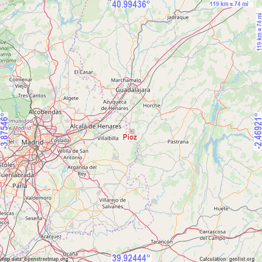
Pioz GPS coordinates[2]
40° 27' 41.508" North, 3° 10' 20.424" West
| Map corner | latitude | longitude |
|---|---|---|
| Upper-left | 40.99436°, | -3.87546° |
| Center: | 40.46153°, | -3.17234° |
| Lower-right: | 39.92444°, | -2.46921° |
| Map W x H: | 119×119 km | = 73.9×73.9mi |
| max Lat: | 43.74134° ⇑62.7% North |
| Pioz: | 40.46153° |
| min Lat: | ⇓37.3% South 27.64134° |
| min Long | Pioz | max Long |
| -18.00367° | -3.17234° | 4.2899° |
| W 51.9%⇐ | ⇒48.1% E |
Elevation
Elevation of Pioz is 865 m = 2838 ft, and this is 267 m = 876 ft above average elevation for this country.
| Max E: |
1682 m = 5518 ft | 23.5% |
| Pioz | 865 m 2838 ft | |
| Avg. | 598 m = 1962 ft | |
Min E: |
0 m = 0 ft | 76.5% |
See also: Spain elevation on elevation.city.
Geographical zone
Pioz is located in North temperate zone (between Tropic of Cancer and the Arctic Circle). Distance of this Northern Tropic circle is 1893 km =1176.3 mi to South.| Distance of | km | miles | from Pioz |
|---|---|---|---|
| North Pole | 5508.2 | 3422.6 | to North |
| Arctic Circle | 2902.3 | 1803.4 | to North |
| Tropic Cancer | 1893 | 1176.3 | to South |
| Equator | 4498.9 | 2795.5 | to South |


Nearby cities:
15 places around Pioz: (largest is in red/bold)
• Anchuelo
8.1 km =5 mi,  272°
272°
• Aranzueque
8.9 km =5.5 mi,  68°
68°
• Corpa
8.6 km =5.3 mi,  240°
240°
• Escariche
11.9 km =7.4 mi,  121°
121°
• Hontoba
11.3 km =7 mi,  94°
94°
• Loranca de Tajuña
5.6 km =3.5 mi,  110°
110°
• Los Santos de la Humosa
8.1 km =5 mi,  301°
301°
• Nuevo Baztán
12 km =7.5 mi,  209°
209°
• Pezuela de las Torres
5 km =3.1 mi,  181°
181°
• Pozo de Guadalajara
3.8 km =2.4 mi,  348°
348°
• Santorcaz
5.4 km =3.4 mi,  282°
282°
• Valdarachas
7.3 km =4.5 mi,  32°
32°
• Valverde de Alcalá
11.6 km =7.2 mi, 244°
• Villalbilla
11.3 km =7 mi,  252°
252°
• Yebes
9.5 km =5.9 mi, 34°
Sources, notices
• [Note1] Compared only with cities in Spain existing in our database
• [Src1] Map data: © OpenStreetMap contributors (CC-BY-SA)
• [Src2] Other city data from geonames.org with taken over terms of usage.
• [Src3] Geographical zone / Annual Mean Temperature by Robert A. Rohde @ Wikipedia
