Valseca geodata
Valseca (Castille and León) is a seat of a third-order administrative division; located in Spain in Europe/Madrid (GMT+2) time zone. With population of 327 people, there are 4397 cities with bigger population in this country. Compared to other cities in Spain, 51.6% of cities are located further ↑North; 62.2% of cities are located further →East and 84.7% of cities have lower elevation than Valseca. Note1
Administrative division(s):
- Level 1: Castille and León
- Level 2: Provincia de Segovia
- Level 3: Valseca


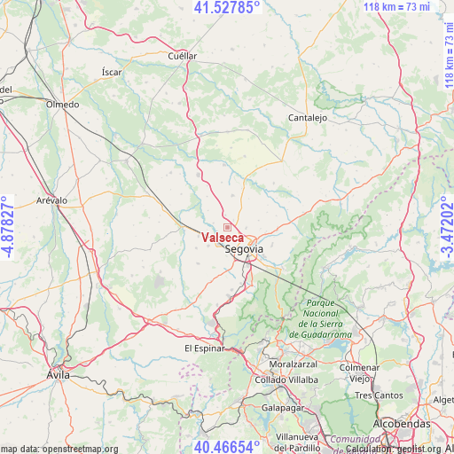
Valseca GPS coordinates[2]
40° 59' 57.588" North, 4° 10' 30.504" West
| Map corner | latitude | longitude |
|---|---|---|
| Upper-left | 41.52785°, | -4.87827° |
| Center: | 40.99933°, | -4.17514° |
| Lower-right: | 40.46654°, | -3.47202° |
| Map W x H: | 118×118 km | = 73.3×73.3mi |
| max Lat: | 43.74134° ⇑51.6% North |
| Valseca: | 40.99933° |
| min Lat: | ⇓48.4% South 27.64134° |
| min Long | Valseca | max Long |
| -18.00367° | -4.17514° | 4.2899° |
| W 37.8%⇐ | ⇒62.2% E |
Elevation
Elevation of Valseca is 948 m = 3110 ft, and this is 350 m = 1148 ft above average elevation for this country.
| Max E: |
1682 m = 5518 ft | 15.3% |
| Valseca | 948 m 3110 ft | |
| Avg. | 598 m = 1962 ft | |
Min E: |
0 m = 0 ft | 84.7% |
See also: Spain elevation on elevation.city.
Geographical zone
Valseca is located in North temperate zone (between Tropic of Cancer and the Arctic Circle). Distance of this Northern Tropic circle is 1952.8 km =1213.4 mi to South.| Distance of | km | miles | from Valseca |
|---|---|---|---|
| North Pole | 5448.4 | 3385.5 | to North |
| Arctic Circle | 2842.5 | 1766.2 | to North |
| Tropic Cancer | 1952.8 | 1213.4 | to South |
| Equator | 4558.7 | 2832.6 | to South |


Nearby cities:
15 places around Valseca: (largest is in red/bold)
• Brieva
10.9 km =6.8 mi,  68°
68°
• Cabañas de Polendos
9.3 km =5.8 mi,  36°
36°
• Cantimpalos
8.4 km =5.2 mi,  8°
8°
• Encinillas
2.5 km =1.6 mi,  34°
34°
• Escobar de Polendos
10.8 km =6.7 mi,  19°
19°
• Espirdo
8.5 km =5.3 mi,  91°
91°
• Garcillán
8 km =5 mi,  252°
252°
• Hontanares de Eresma
3.1 km =1.9 mi,  233°
233°
• La Lastrilla
6.9 km =4.3 mi,  120°
120°
• Martín Miguel
9.6 km =6 mi,  237°
237°
• Roda de Eresma
3.3 km =2.1 mi,  350°
350°
• San Cristóbal de Segovia
9.8 km =6.1 mi, 122°
• Segovia
7.4 km =4.6 mi,  140°
140°
• Valverde del Majano
6.9 km =4.3 mi, 226°
• Yanguas de Eresma
9.7 km =6 mi,  326°
326°
Sources, notices
• [Note1] Compared only with cities in Spain existing in our database
• [Src1] Map data: © OpenStreetMap contributors (CC-BY-SA)
• [Src2] Other city data from geonames.org with taken over terms of usage.
• [Src3] Geographical zone / Annual Mean Temperature by Robert A. Rohde @ Wikipedia
