Roda de Eresma geodata
Roda de Eresma (Castille and León) is a seat of a third-order administrative division; located in Spain in Europe/Madrid (GMT+2) time zone. With population of 128 people, there are 5608 cities with bigger population in this country. Compared to other cities in Spain, 50.9% of cities are located further ↑North; 62.3% of cities are located further →East and 83.9% of cities have lower elevation than Roda de Eresma. Note1
Administrative division(s):
- Level 1: Castille and León
- Level 2: Provincia de Segovia
- Level 3: Roda de Eresma


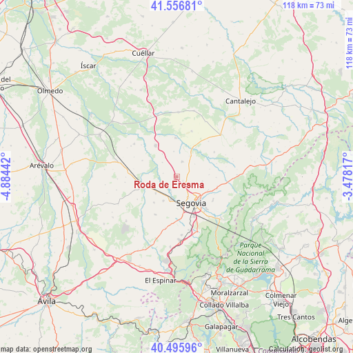
Roda de Eresma GPS coordinates[2]
41° 1' 42.672" North, 4° 10' 52.68" West
| Map corner | latitude | longitude |
|---|---|---|
| Upper-left | 41.55681°, | -4.88442° |
| Center: | 41.02852°, | -4.1813° |
| Lower-right: | 40.49596°, | -3.47817° |
| Map W x H: | 118×118 km | = 73.3×73.3mi |
| max Lat: | 43.74134° ⇑50.9% North |
| Roda de Eresma: | 41.02852° |
| min Lat: | ⇓49.1% South 27.64134° |
| min Long | Roda de Eresma | max Long |
| -18.00367° | -4.1813° | 4.2899° |
| W 37.7%⇐ | ⇒62.3% E |
Elevation
Elevation of Roda de Eresma is 939 m = 3081 ft, and this is 341 m = 1119 ft above average elevation for this country.
| Max E: |
1682 m = 5518 ft | 16.1% |
| Roda de Eresma | 939 m 3081 ft | |
| Avg. | 598 m = 1962 ft | |
Min E: |
0 m = 0 ft | 83.9% |
See also: Spain elevation on elevation.city.
Geographical zone
Roda de Eresma is located in North temperate zone (between Tropic of Cancer and the Arctic Circle). Distance of this Northern Tropic circle is 1956 km =1215.4 mi to South.| Distance of | km | miles | from Roda de Eresma |
|---|---|---|---|
| North Pole | 5445.1 | 3383.4 | to North |
| Arctic Circle | 2839.2 | 1764.2 | to North |
| Tropic Cancer | 1956 | 1215.4 | to South |
| Equator | 4561.9 | 2834.6 | to South |


Nearby cities:
15 places around Roda de Eresma: (largest is in red/bold)
• Añe
9.6 km =6 mi,  275°
275°
• Cabañas de Polendos
7.3 km =4.5 mi,  54°
54°
• Cantimpalos
5.4 km =3.4 mi,  19°
19°
• Encinillas
2.3 km =1.4 mi,  120°
120°
• Escarabajosa de Cabezas
8.5 km =5.3 mi,  352°
352°
• Escobar de Polendos
8.1 km =5 mi,  31°
31°
• Espirdo
9.7 km =6 mi,  110°
110°
• Garcillán
9.1 km =5.7 mi,  231°
231°
• Hontanares de Eresma
5.4 km =3.4 mi,  200°
200°
• La Lastrilla
9.3 km =5.8 mi,  136°
136°
• Segovia
10.4 km =6.5 mi,  149°
149°
• Tabanera la Luenga
9 km =5.6 mi,  327°
327°
• Valseca
3.3 km =2.1 mi,  170°
170°
• Valverde del Majano
9.1 km =5.7 mi,  209°
209°
• Yanguas de Eresma
6.8 km =4.2 mi,  314°
314°
Sources, notices
• [Note1] Compared only with cities in Spain existing in our database
• [Src1] Map data: © OpenStreetMap contributors (CC-BY-SA)
• [Src2] Other city data from geonames.org with taken over terms of usage.
• [Src3] Geographical zone / Annual Mean Temperature by Robert A. Rohde @ Wikipedia
