Segovia geodata
Segovia (Castille and León) is a seat of a second-order administrative division; located in Spain in Europe/Madrid (GMT+2) time zone. With population of 56,660 people, there are 166 cities with bigger population in this country. Compared to other cities in Spain, 52.9% of cities are located further ↑North; 61.5% of cities are located further →East and 87.9% of cities have lower elevation than Segovia. Note1
Administrative division(s):
- Level 1: Castille and León
- Level 2: Provincia de Segovia
- Level 3: Segovia


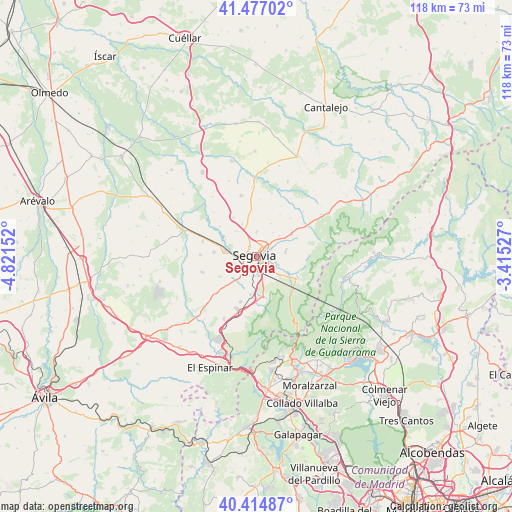
Segovia GPS coordinates[2]
40° 56' 53.088" North, 4° 7' 6.204" West
| Map corner | latitude | longitude |
|---|---|---|
| Upper-left | 41.47702°, | -4.82152° |
| Center: | 40.94808°, | -4.11839° |
| Lower-right: | 40.41487°, | -3.41527° |
| Map W x H: | 118.1×118.1 km | = 73.4×73.4mi |
| max Lat: | 43.74134° ⇑52.9% North |
| Segovia: | 40.94808° |
| min Lat: | ⇓47.1% South 27.64134° |
| min Long | Segovia | max Long |
| -18.00367° | -4.11839° | 4.2899° |
| W 38.5%⇐ | ⇒61.5% E |
Elevation
Elevation of Segovia is 996 m = 3268 ft, and this is 398 m = 1306 ft above average elevation for this country.
| Max E: |
1682 m = 5518 ft | 12.1% |
| Segovia | 996 m 3268 ft | |
| Avg. | 598 m = 1962 ft | |
Min E: |
0 m = 0 ft | 87.9% |
See also: Segovia elevation on elevation.city.
Geographical zone
Segovia is located in North temperate zone (between Tropic of Cancer and the Arctic Circle). Distance of this Northern Tropic circle is 1947.1 km =1209.9 mi to South.| Distance of | km | miles | from Segovia |
|---|---|---|---|
| North Pole | 5454.1 | 3389 | to North |
| Arctic Circle | 2848.2 | 1769.8 | to North |
| Tropic Cancer | 1947.1 | 1209.9 | to South |
| Equator | 4553 | 2829.1 | to South |


Nearby cities:
15 places around Segovia: (largest is in red/bold)
• Basardilla
11.7 km =7.3 mi,  41°
41°
• Brieva
11.1 km =6.9 mi,  29°
29°
• Encinillas
8.5 km =5.3 mi,  336°
336°
• Espirdo
6.7 km =4.2 mi, 34°
• Hontanares de Eresma
8.2 km =5.1 mi,  298°
298°
• La Lastrilla
2.5 km =1.6 mi, 27°
• Ortigosa del Monte
12.8 km =8 mi,  202°
202°
• Palazuelos de Eresma
5.2 km =3.2 mi,  111°
111°
• Roda de Eresma
10.4 km =6.5 mi,  329°
329°
• San Cristóbal de Segovia
3.5 km =2.2 mi,  82°
82°
• San Ildefonso
10.7 km =6.6 mi,  118°
118°
• Torrecaballeros
9.3 km =5.8 mi,  58°
58°
• Trescasas
7.2 km =4.5 mi, 75°
• Valseca
7.4 km =4.6 mi,  320°
320°
• Valverde del Majano
9.8 km =6.1 mi,  275°
275°
Sources, notices
• [Note1] Compared only with cities in Spain existing in our database
• [Src1] Map data: © OpenStreetMap contributors (CC-BY-SA)
• [Src2] Other city data from geonames.org with taken over terms of usage.
• [Src3] Geographical zone / Annual Mean Temperature by Robert A. Rohde @ Wikipedia
