Valmojado geodata
Valmojado (Castille-La Mancha) is a seat of a third-order administrative division; located in Spain in Europe/Madrid (GMT+2) time zone. With population of 2,887 people, there are 1761 cities with bigger population in this country. Compared to other cities in Spain, 67.1% of cities are located further ↑North; 61.1% of cities are located further →East and 50.4% of cities have higher elevation than Valmojado. Note1
Administrative division(s):
- Level 1: Castille-La Mancha
- Level 2: Province of Toledo
- Level 3: Valmojado


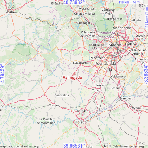
Valmojado GPS coordinates[2]
40° 12' 15.984" North, 4° 5' 29.256" West
| Map corner | latitude | longitude |
|---|---|---|
| Upper-left | 40.73932°, | -4.79459° |
| Center: | 40.20444°, | -4.09146° |
| Lower-right: | 39.66531°, | -3.38834° |
| Map W x H: | 119.4×119.4 km | = 74.2×74.2mi |
| max Lat: | 43.74134° ⇑67.1% North |
| Valmojado: | 40.20444° |
| min Lat: | ⇓32.9% South 27.64134° |
| min Long | Valmojado | max Long |
| -18.00367° | -4.09146° | 4.2899° |
| W 38.9%⇐ | ⇒61.1% E |
Elevation
Elevation of Valmojado is 654 m = 2146 ft, and this is 56 m = 184 ft above average elevation for this country.
| Max E: |
1682 m = 5518 ft | 50.4% |
| Valmojado | 654 m 2146 ft | |
| Avg. | 598 m = 1962 ft | |
Min E: |
0 m = 0 ft | 49.6% |
See also: Spain elevation on elevation.city.
Geographical zone
Valmojado is located in North temperate zone (between Tropic of Cancer and the Arctic Circle). Distance of this Northern Tropic circle is 1864.4 km =1158.5 mi to South.| Distance of | km | miles | from Valmojado |
|---|---|---|---|
| North Pole | 5536.7 | 3440.3 | to North |
| Arctic Circle | 2930.9 | 1821.2 | to North |
| Tropic Cancer | 1864.4 | 1158.5 | to South |
| Equator | 4470.3 | 2777.7 | to South |


Nearby cities:
15 places around Valmojado: (largest is in red/bold)
• Arroyomolinos
16.3 km =10.1 mi,  63°
63°
• Batres
14.3 km =8.9 mi,  87°
87°
• Camarena
12.6 km =7.8 mi,  190°
190°
• Casarrubios del Monte
5.1 km =3.2 mi,  112°
112°
• Chozas de Canales
12.3 km =7.6 mi,  160°
160°
• El Álamo
8.7 km =5.4 mi,  70°
70°
• La Torre de Esteban Hambrán
11.2 km =7 mi,  249°
249°
• Las Ventas de Retamosa
5.8 km =3.6 mi,  199°
199°
• Méntrida
9.5 km =5.9 mi,  293°
293°
• Navalcarnero
11.6 km =7.2 mi,  35°
35°
• Palomeque
14.4 km =8.9 mi,  131°
131°
• Santa Cruz del Retamar
15.9 km =9.9 mi,  233°
233°
• Villamanta
10.6 km =6.6 mi,  351°
351°
• Villamantilla
15.3 km =9.5 mi, 347°
• Villanueva de Perales
15.7 km =9.8 mi,  357°
357°
Sources, notices
• [Note1] Compared only with cities in Spain existing in our database
• [Src1] Map data: © OpenStreetMap contributors (CC-BY-SA)
• [Src2] Other city data from geonames.org with taken over terms of usage.
• [Src3] Geographical zone / Annual Mean Temperature by Robert A. Rohde @ Wikipedia
