Palomeque geodata
Palomeque (Castille-La Mancha) is a seat of a third-order administrative division; located in Spain in Europe/Madrid (GMT+2) time zone. With population of 835 people, there are 3158 cities with bigger population in this country. Compared to other cities in Spain, 68.4% of cities are located further ↑North; 59.1% of cities are located further →East and 54.4% of cities have higher elevation than Palomeque. Note1
Administrative division(s):
- Level 1: Castille-La Mancha
- Level 2: Province of Toledo
- Level 3: Palomeque


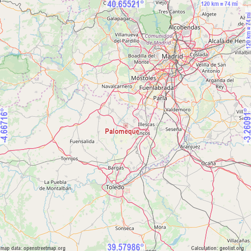
Palomeque GPS coordinates[2]
40° 7' 10.776" North, 3° 57' 50.508" West
| Map corner | latitude | longitude |
|---|---|---|
| Upper-left | 40.65521°, | -4.66716° |
| Center: | 40.11966°, | -3.96403° |
| Lower-right: | 39.57986°, | -3.26091° |
| Map W x H: | 119.6×119.6 km | = 74.3×74.3mi |
| max Lat: | 43.74134° ⇑68.4% North |
| Palomeque: | 40.11966° |
| min Lat: | ⇓31.6% South 27.64134° |
| min Long | Palomeque | max Long |
| -18.00367° | -3.96403° | 4.2899° |
| W 40.9%⇐ | ⇒59.1% E |
Elevation
Elevation of Palomeque is 605 m = 1985 ft, and this is 7 m = 23 ft above average elevation for this country.
| Max E: |
1682 m = 5518 ft | 54.4% |
| Palomeque | 605 m 1985 ft | |
| Avg. | 598 m = 1962 ft | |
Min E: |
0 m = 0 ft | 45.6% |
See also: Spain elevation on elevation.city.
Geographical zone
Palomeque is located in North temperate zone (between Tropic of Cancer and the Arctic Circle). Distance of this Northern Tropic circle is 1855 km =1152.6 mi to South.| Distance of | km | miles | from Palomeque |
|---|---|---|---|
| North Pole | 5546.2 | 3446.2 | to North |
| Arctic Circle | 2940.3 | 1827 | to North |
| Tropic Cancer | 1855 | 1152.6 | to South |
| Equator | 4460.9 | 2771.9 | to South |


Nearby cities:
15 places around Palomeque: (largest is in red/bold)
• Batres
10.6 km =6.6 mi,  19°
19°
• Carranque
7.7 km =4.8 mi,  43°
43°
• Casarrubios del Monte
9.7 km =6 mi,  320°
320°
• Cedillo del Condado
3.7 km =2.3 mi,  102°
102°
• Chozas de Canales
7.1 km =4.4 mi,  252°
252°
• El Viso de San Juan
4.6 km =2.9 mi,  58°
58°
• El Álamo
12.6 km =7.8 mi,  348°
348°
• Illescas
10 km =6.2 mi,  88°
88°
• Lominchar
3.2 km =2 mi,  184°
184°
• Numancia de la Sagra
10.9 km =6.8 mi,  117°
117°
• Recas
7.8 km =4.8 mi,  197°
197°
• Serranillos del Valle
11.5 km =7.1 mi, 37°
• Ugena
8.5 km =5.3 mi, 61°
• Yuncler
10.3 km =6.4 mi,  148°
148°
• Yuncos
8.8 km =5.5 mi, 115°
Sources, notices
• [Note1] Compared only with cities in Spain existing in our database
• [Src1] Map data: © OpenStreetMap contributors (CC-BY-SA)
• [Src2] Other city data from geonames.org with taken over terms of usage.
• [Src3] Geographical zone / Annual Mean Temperature by Robert A. Rohde @ Wikipedia
