Las Ventas de Retamosa geodata
Las Ventas de Retamosa (Castille-La Mancha) is a populated place; located in Spain in Europe/Madrid (GMT+2) time zone. With population of 1,432 people, there are 2524 cities with bigger population in this country. Compared to other cities in Spain, 67.9% of cities are located further ↑North; 61.4% of cities are located further →East and 52.9% of cities have higher elevation than Las Ventas de Retamosa. Note1
Administrative division(s):
- Level 1: Castille-La Mancha
- Level 2: Province of Toledo
- Level 3: Ventas de Retamosa, Las


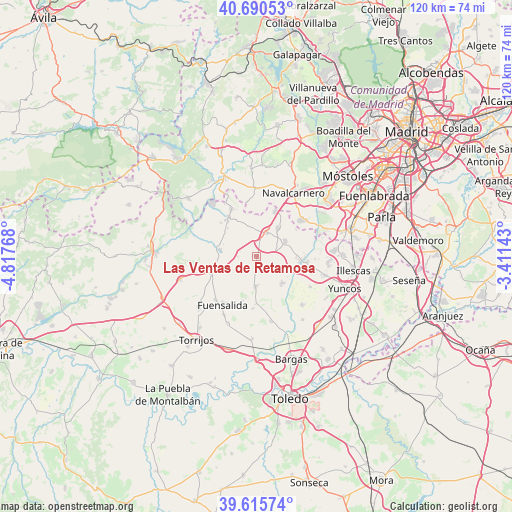
Las Ventas de Retamosa GPS coordinates[2]
40° 9' 18.936" North, 4° 6' 52.38" West
| Map corner | latitude | longitude |
|---|---|---|
| Upper-left | 40.69053°, | -4.81768° |
| Center: | 40.15526°, | -4.11455° |
| Lower-right: | 39.61574°, | -3.41143° |
| Map W x H: | 119.5×119.5 km | = 74.3×74.3mi |
| max Lat: | 43.74134° ⇑67.9% North |
| Las Ventas de Retamosa: | 40.15526° |
| min Lat: | ⇓32.1% South 27.64134° |
| min Long | Las Ventas de R | max Long |
| -18.00367° | -4.11455° | 4.2899° |
| W 38.6%⇐ | ⇒61.4% E |
Elevation
Elevation of Las Ventas de Retamosa is 625 m = 2051 ft, and this is 27 m = 89 ft above average elevation for this country.
| Max E: |
1682 m = 5518 ft | 52.9% |
| Las Ventas de Retamosa | 625 m 2051 ft | |
| Avg. | 598 m = 1962 ft | |
Min E: |
0 m = 0 ft | 47.1% |
See also: Spain elevation on elevation.city.
Geographical zone
Las Ventas de Retamosa is located in North temperate zone (between Tropic of Cancer and the Arctic Circle). Distance of this Northern Tropic circle is 1858.9 km =1155.1 mi to South.| Distance of | km | miles | from Las Ventas de Retamosa |
|---|---|---|---|
| North Pole | 5542.2 | 3443.8 | to North |
| Arctic Circle | 2936.3 | 1824.5 | to North |
| Tropic Cancer | 1858.9 | 1155.1 | to South |
| Equator | 4464.8 | 2774.3 | to South |


Nearby cities:
15 places around Las Ventas de Retamosa: (largest is in red/bold)
• Arcicóllar
11.1 km =6.9 mi,  180°
180°
• Camarena
6.9 km =4.3 mi, 183°
• Camarenilla
15.7 km =9.8 mi,  168°
168°
• Casarrubios del Monte
7.5 km =4.7 mi,  62°
62°
• Chozas de Canales
8.6 km =5.3 mi,  135°
135°
• El Álamo
13.2 km =8.2 mi,  50°
50°
• Fuensalida
13.8 km =8.6 mi,  214°
214°
• La Torre de Esteban Hambrán
8.7 km =5.4 mi,  280°
280°
• Lominchar
14.4 km =8.9 mi,  119°
119°
• Méntrida
11.5 km =7.1 mi,  324°
324°
• Palomeque
13.4 km =8.3 mi,  107°
107°
• Portillo de Toledo
14 km =8.7 mi,  223°
223°
• Recas
15.5 km =9.6 mi, 137°
• Santa Cruz del Retamar
11.5 km =7.1 mi,  249°
249°
• Valmojado
5.8 km =3.6 mi,  19°
19°
Sources, notices
• [Note1] Compared only with cities in Spain existing in our database
• [Src1] Map data: © OpenStreetMap contributors (CC-BY-SA)
• [Src2] Other city data from geonames.org with taken over terms of usage.
• [Src3] Geographical zone / Annual Mean Temperature by Robert A. Rohde @ Wikipedia
