Camarena geodata
Camarena (Castille-La Mancha) is a seat of a third-order administrative division; located in Spain in Europe/Madrid (GMT+2) time zone. With population of 2,704 people, there are 1815 cities with bigger population in this country. Compared to other cities in Spain, 68.9% of cities are located further ↑North; 61.5% of cities are located further →East and 56.3% of cities have higher elevation than Camarena. Note1
Administrative division(s):
- Level 1: Castille-La Mancha
- Level 2: Province of Toledo
- Level 3: Camarena


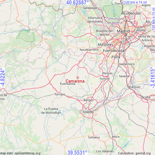
Camarena GPS coordinates[2]
40° 5' 35.196" North, 4° 7' 9.372" West
| Map corner | latitude | longitude |
|---|---|---|
| Upper-left | 40.62887°, | -4.8224° |
| Center: | 40.09311°, | -4.11927° |
| Lower-right: | 39.5531°, | -3.41615° |
| Map W x H: | 119.6×119.6 km | = 74.3×74.3mi |
| max Lat: | 43.74134° ⇑68.9% North |
| Camarena: | 40.09311° |
| min Lat: | ⇓31.1% South 27.64134° |
| min Long | Camarena | max Long |
| -18.00367° | -4.11927° | 4.2899° |
| W 38.5%⇐ | ⇒61.5% E |
Elevation
Elevation of Camarena is 576 m = 1890 ft, and this is 22 m = 72 ft below average elevation for this country.
| Max E: |
1682 m = 5518 ft | 56.3% |
| Avg. | 598 m = 1962 ft | |
| Camarena | 576 m = 1890 ft | |
Min E: |
0 m = 0 ft | 43.7% |
See also: Spain elevation on elevation.city.
Geographical zone
Camarena is located in North temperate zone (between Tropic of Cancer and the Arctic Circle). Distance of this Northern Tropic circle is 1852 km =1150.8 mi to South.| Distance of | km | miles | from Camarena |
|---|---|---|---|
| North Pole | 5549.1 | 3448 | to North |
| Arctic Circle | 2943.2 | 1828.8 | to North |
| Tropic Cancer | 1852 | 1150.8 | to South |
| Equator | 4457.9 | 2770 | to South |


Nearby cities:
15 places around Camarena: (largest is in red/bold)
• Arcicóllar
4.2 km =2.6 mi,  176°
176°
• Camarenilla
9.2 km =5.7 mi,  156°
156°
• Casarrubios del Monte
12.6 km =7.8 mi,  34°
34°
• Chozas de Canales
6.5 km =4 mi,  83°
83°
• Fuensalida
8.7 km =5.4 mi,  239°
239°
• Huecas
11.1 km =6.9 mi,  215°
215°
• La Torre de Esteban Hambrán
11.8 km =7.3 mi,  316°
316°
• Las Ventas de Retamosa
6.9 km =4.3 mi,  3°
3°
• Lominchar
12.9 km =8 mi,  91°
91°
• Novés
14.2 km =8.8 mi,  249°
249°
• Palomeque
13.5 km =8.4 mi, 77°
• Portillo de Toledo
9.8 km =6.1 mi, 250°
• Recas
11.8 km =7.3 mi,  112°
112°
• Santa Cruz del Retamar
10.8 km =6.7 mi,  285°
285°
• Valmojado
12.6 km =7.8 mi,  10°
10°
Sources, notices
• [Note1] Compared only with cities in Spain existing in our database
• [Src1] Map data: © OpenStreetMap contributors (CC-BY-SA)
• [Src2] Other city data from geonames.org with taken over terms of usage.
• [Src3] Geographical zone / Annual Mean Temperature by Robert A. Rohde @ Wikipedia
