Vallirana geodata
Vallirana (Catalonia) is a seat of a third-order administrative division; located in Spain in Europe/Madrid (GMT+2) time zone. With population of 14,066 people, there are 657 cities with bigger population in this country. Compared to other cities in Spain, 57.3% of cities are located further ↓South; 93.2% of cities are located further ←West and 81.8% of cities have higher elevation than Vallirana. Note1


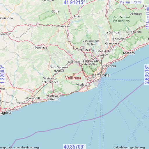
Vallirana GPS coordinates[2]
41° 23' 12.336" North, 1° 55' 55.38" East
| Map corner | latitude | longitude |
|---|---|---|
| Upper-left | 41.91215°, | 1.22893° |
| Center: | 41.38676°, | 1.93205° |
| Lower-right: | 40.85709°, | 2.63518° |
| Map W x H: | 117.3×117.3 km | = 72.9×72.9mi |
| max Lat: | 43.74134° ⇑42.7% North |
| Vallirana: | 41.38676° |
| min Lat: | ⇓57.3% South 27.64134° |
| min Long | Vallirana | max Long |
| -18.00367° | 1.93205° | 4.2899° |
| W 93.2%⇐ | ⇒6.8% E |
Elevation
Elevation of Vallirana is 191 m = 627 ft, and this is 407 m = 1335 ft below average elevation for this country.
| Max E: |
1682 m = 5518 ft | 81.8% |
| Avg. | 598 m = 1962 ft | |
| Vallirana | 191 m = 627 ft | |
Min E: |
0 m = 0 ft | 18.2% |
See also: Spain elevation on elevation.city.
Geographical zone
Vallirana is located in North temperate zone (between Tropic of Cancer and the Arctic Circle). Distance of this Northern Tropic circle is 1995.9 km =1240.2 mi to South.| Distance of | km | miles | from Vallirana |
|---|---|---|---|
| North Pole | 5405.3 | 3358.7 | to North |
| Arctic Circle | 2799.4 | 1739.5 | to North |
| Tropic Cancer | 1995.9 | 1240.2 | to South |
| Equator | 4601.8 | 2859.4 | to South |


Nearby cities:
15 places around Vallirana: (largest is in red/bold)
• Begues
5.9 km =3.7 mi,  178°
178°
• Castellví de Rosanes
7.5 km =4.7 mi,  339°
339°
• Cervelló
2.5 km =1.6 mi,  65°
65°
• Corbera de Llobregat
3.5 km =2.2 mi, 342°
• Gelida
7.5 km =4.7 mi,  313°
313°
• Martorell
9.7 km =6 mi,  359°
359°
• Molins de Rei
7.8 km =4.8 mi,  64°
64°
• Olesa de Bonesvalls
7.8 km =4.8 mi,  242°
242°
• Pallejà
6.7 km =4.2 mi,  51°
51°
• Sant Andreu de la Barca
7.4 km =4.6 mi,  26°
26°
• Sant Feliu de Llobregat
9.8 km =6.1 mi,  92°
92°
• Sant Vicenç dels Horts
6.3 km =3.9 mi,  83°
83°
• Santa Coloma de Cervelló
7.2 km =4.5 mi,  107°
107°
• Subirats
8.4 km =5.2 mi,  280°
280°
• Torrelles de Llobregat
5.9 km =3.7 mi,  133°
133°
Sources, notices
• [Note1] Compared only with cities in Spain existing in our database
• [Src1] Map data: © OpenStreetMap contributors (CC-BY-SA)
• [Src2] Other city data from geonames.org with taken over terms of usage.
• [Src3] Geographical zone / Annual Mean Temperature by Robert A. Rohde @ Wikipedia
