Gelida geodata
Gelida (Catalonia) is a seat of a third-order administrative division; located in Spain in Europe/Madrid (GMT+2) time zone. With population of 5,750 people, there are 1168 cities with bigger population in this country. Compared to other cities in Spain, 59% of cities are located further ↓South; 92.9% of cities are located further ←West and 78.2% of cities have higher elevation than Gelida. Note1


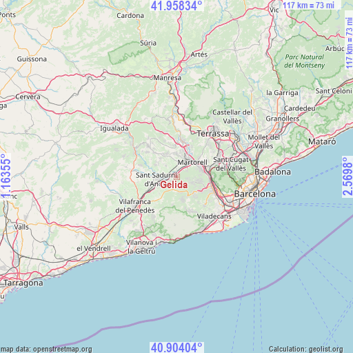
Gelida GPS coordinates[2]
41° 25' 59.988" North, 1° 52' 0.012" East
| Map corner | latitude | longitude |
|---|---|---|
| Upper-left | 41.95834°, | 1.16355° |
| Center: | 41.43333°, | 1.86667° |
| Lower-right: | 40.90404°, | 2.5698° |
| Map W x H: | 117.2×117.2 km | = 72.8×72.8mi |
| max Lat: | 43.74134° ⇑41% North |
| Gelida: | 41.43333° |
| min Lat: | ⇓59% South 27.64134° |
| min Long | Gelida | max Long |
| -18.00367° | 1.86667° | 4.2899° |
| W 92.9%⇐ | ⇒7.1% E |
Elevation
Elevation of Gelida is 252 m = 827 ft, and this is 346 m = 1135 ft below average elevation for this country.
| Max E: |
1682 m = 5518 ft | 78.2% |
| Avg. | 598 m = 1962 ft | |
| Gelida | 252 m = 827 ft | |
Min E: |
0 m = 0 ft | 21.8% |
See also: Spain elevation on elevation.city.
Geographical zone
Gelida is located in North temperate zone (between Tropic of Cancer and the Arctic Circle). Distance of this Northern Tropic circle is 2001 km =1243.4 mi to South.| Distance of | km | miles | from Gelida |
|---|---|---|---|
| North Pole | 5400.1 | 3355.5 | to North |
| Arctic Circle | 2794.2 | 1736.2 | to North |
| Tropic Cancer | 2001 | 1243.4 | to South |
| Equator | 4607 | 2862.7 | to South |


Nearby cities:
15 places around Gelida: (largest is in red/bold)
• Abrera
9.7 km =6 mi,  17°
17°
• Avinyonet del Penedès
11.6 km =7.2 mi,  216°
216°
• Castellbisbal
10.7 km =6.6 mi,  64°
64°
• Castellví de Rosanes
3.3 km =2.1 mi, 56°
• Cervelló
8.8 km =5.5 mi,  118°
118°
• Corbera de Llobregat
4.8 km =3 mi,  112°
112°
• Martorell
7 km =4.3 mi,  49°
49°
• Masquefa
9.1 km =5.7 mi,  329°
329°
• Olesa de Bonesvalls
8.9 km =5.5 mi,  189°
189°
• Pallejà
10.8 km =6.7 mi,  95°
95°
• Sant Andreu de la Barca
8.9 km =5.5 mi,  80°
80°
• Sant Llorenç d'Hortons
4.6 km =2.9 mi,  323°
323°
• Sant Sadurní d'Anoia
6.8 km =4.2 mi,  262°
262°
• Subirats
4.6 km =2.9 mi, 216°
• Vallirana
7.5 km =4.7 mi,  133°
133°
Sources, notices
• [Note1] Compared only with cities in Spain existing in our database
• [Src1] Map data: © OpenStreetMap contributors (CC-BY-SA)
• [Src2] Other city data from geonames.org with taken over terms of usage.
• [Src3] Geographical zone / Annual Mean Temperature by Robert A. Rohde @ Wikipedia
