Corbera de Llobregat geodata
Corbera de Llobregat (Catalonia) is a seat of a third-order administrative division; located in Spain in Europe/Madrid (GMT+2) time zone. With population of 13,843 people, there are 669 cities with bigger population in this country. Compared to other cities in Spain, 58.4% of cities are located further ↓South; 93.1% of cities are located further ←West and 73.2% of cities have higher elevation than Corbera de Llobregat. Note1
Administrative division(s):
- Level 1: Catalonia
- Level 2: Província de Barcelona
- Level 3: Corbera de Llobregat


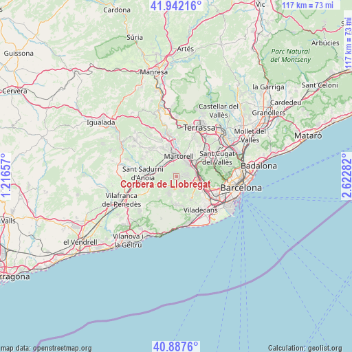
Corbera de Llobregat GPS coordinates[2]
41° 25' 1.272" North, 1° 55' 10.92" East
| Map corner | latitude | longitude |
|---|---|---|
| Upper-left | 41.94216°, | 1.21657° |
| Center: | 41.41702°, | 1.9197° |
| Lower-right: | 40.8876°, | 2.62282° |
| Map W x H: | 117.3×117.3 km | = 72.9×72.9mi |
| max Lat: | 43.74134° ⇑41.6% North |
| Corbera de Llobregat: | 41.41702° |
| min Lat: | ⇓58.4% South 27.64134° |
| min Long | Corbera de Llob | max Long |
| -18.00367° | 1.9197° | 4.2899° |
| W 93.1%⇐ | ⇒6.9% E |
Elevation
Elevation of Corbera de Llobregat is 327 m = 1073 ft, and this is 271 m = 889 ft below average elevation for this country.
| Max E: |
1682 m = 5518 ft | 73.2% |
| Avg. | 598 m = 1962 ft | |
| Corbera de Llobregat | 327 m = 1073 ft | |
Min E: |
0 m = 0 ft | 26.8% |
See also: Spain elevation on elevation.city.
Geographical zone
Corbera de Llobregat is located in North temperate zone (between Tropic of Cancer and the Arctic Circle). Distance of this Northern Tropic circle is 1999.2 km =1242.2 mi to South.| Distance of | km | miles | from Corbera de Llobregat |
|---|---|---|---|
| North Pole | 5401.9 | 3356.6 | to North |
| Arctic Circle | 2796 | 1737.4 | to North |
| Tropic Cancer | 1999.2 | 1242.2 | to South |
| Equator | 4605.1 | 2861.5 | to South |


Nearby cities:
15 places around Corbera de Llobregat: (largest is in red/bold)
• Begues
9.4 km =5.8 mi,  173°
173°
• Castellbisbal
8.3 km =5.2 mi,  38°
38°
• Castellví de Rosanes
4 km =2.5 mi,  335°
335°
• Cervelló
4 km =2.5 mi,  125°
125°
• Gelida
4.8 km =3 mi,  292°
292°
• Martorell
6.4 km =4 mi,  8°
8°
• Molins de Rei
8.1 km =5 mi,  90°
90°
• Olesa de Bonesvalls
9.1 km =5.7 mi,  220°
220°
• Pallejà
6.3 km =3.9 mi,  83°
83°
• Sant Andreu de la Barca
5.5 km =3.4 mi,  52°
52°
• Sant Llorenç d'Hortons
9.1 km =5.7 mi,  307°
307°
• Sant Vicenç dels Horts
7.7 km =4.8 mi,  110°
110°
• Subirats
7.4 km =4.6 mi,  255°
255°
• Torrelles de Llobregat
9.1 km =5.7 mi,  144°
144°
• Vallirana
3.5 km =2.2 mi,  162°
162°
Sources, notices
• [Note1] Compared only with cities in Spain existing in our database
• [Src1] Map data: © OpenStreetMap contributors (CC-BY-SA)
• [Src2] Other city data from geonames.org with taken over terms of usage.
• [Src3] Geographical zone / Annual Mean Temperature by Robert A. Rohde @ Wikipedia
