Begues geodata
Begues (Catalonia) is a seat of a third-order administrative division; located in Spain in Europe/Madrid (GMT+2) time zone. With population of 5,538 people, there are 1204 cities with bigger population in this country. Compared to other cities in Spain, 55.9% of cities are located further ↓South; 93.2% of cities are located further ←West and 68.3% of cities have higher elevation than Begues. Note1


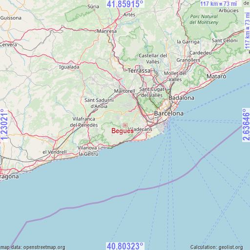
Begues GPS coordinates[2]
41° 19' 59.988" North, 1° 55' 59.988" East
| Map corner | latitude | longitude |
|---|---|---|
| Upper-left | 41.85915°, | 1.23021° |
| Center: | 41.33333°, | 1.93333° |
| Lower-right: | 40.80323°, | 2.63646° |
| Map W x H: | 117.4×117.4 km | = 72.9×72.9mi |
| max Lat: | 43.74134° ⇑44.1% North |
| Begues: | 41.33333° |
| min Lat: | ⇓55.9% South 27.64134° |
| min Long | Begues | max Long |
| -18.00367° | 1.93333° | 4.2899° |
| W 93.2%⇐ | ⇒6.8% E |
Elevation
Elevation of Begues is 412 m = 1352 ft, and this is 186 m = 610 ft below average elevation for this country.
| Max E: |
1682 m = 5518 ft | 68.3% |
| Avg. | 598 m = 1962 ft | |
| Begues | 412 m = 1352 ft | |
Min E: |
0 m = 0 ft | 31.7% |
See also: Spain elevation on elevation.city.
Geographical zone
Begues is located in North temperate zone (between Tropic of Cancer and the Arctic Circle). Distance of this Northern Tropic circle is 1989.9 km =1236.5 mi to South.| Distance of | km | miles | from Begues |
|---|---|---|---|
| North Pole | 5411.2 | 3362.4 | to North |
| Arctic Circle | 2805.3 | 1743.1 | to North |
| Tropic Cancer | 1989.9 | 1236.5 | to South |
| Equator | 4595.8 | 2855.7 | to South |


Nearby cities:
15 places around Begues: (largest is in red/bold)
• Castelldefels
6.9 km =4.3 mi,  153°
153°
• Cervelló
7.3 km =4.5 mi,  17°
17°
• Corbera de Llobregat
9.4 km =5.8 mi,  353°
353°
• Gavà
6.4 km =4 mi,  118°
118°
• Olesa de Bonesvalls
7.4 km =4.6 mi,  288°
288°
• Olivella
9.9 km =6.2 mi,  259°
259°
• Sant Boi de Llobregat
8.7 km =5.4 mi,  82°
82°
• Sant Feliu de Llobregat
11.2 km =7 mi,  60°
60°
• Sant Joan Despí
11 km =6.8 mi,  70°
70°
• Sant Vicenç dels Horts
9.1 km =5.7 mi,  42°
42°
• Santa Coloma de Cervelló
7.7 km =4.8 mi, 60°
• Subirats
11.2 km =7 mi,  311°
311°
• Torrelles de Llobregat
4.6 km =2.9 mi, 66°
• Vallirana
5.9 km =3.7 mi,  358°
358°
• Viladecans
7.1 km =4.4 mi,  107°
107°
Sources, notices
• [Note1] Compared only with cities in Spain existing in our database
• [Src1] Map data: © OpenStreetMap contributors (CC-BY-SA)
• [Src2] Other city data from geonames.org with taken over terms of usage.
• [Src3] Geographical zone / Annual Mean Temperature by Robert A. Rohde @ Wikipedia
