Cervelló geodata
Cervelló (Catalonia) is a seat of a third-order administrative division; located in Spain in Europe/Madrid (GMT+2) time zone. With population of 7,151 people, there are 1019 cities with bigger population in this country. Compared to other cities in Spain, 57.6% of cities are located further ↓South; 93.3% of cities are located further ←West and 86.2% of cities have higher elevation than Cervelló. Note1


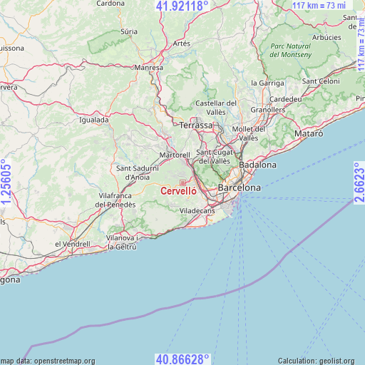
Cervelló GPS coordinates[2]
41° 23' 45.132" North, 1° 57' 33.012" East
| Map corner | latitude | longitude |
|---|---|---|
| Upper-left | 41.92118°, | 1.25605° |
| Center: | 41.39587°, | 1.95917° |
| Lower-right: | 40.86628°, | 2.6623° |
| Map W x H: | 117.3×117.3 km | = 72.9×72.9mi |
| max Lat: | 43.74134° ⇑42.4% North |
| Cervelló: | 41.39587° |
| min Lat: | ⇓57.6% South 27.64134° |
| min Long | Cervelló | max Long |
| -18.00367° | 1.95917° | 4.2899° |
| W 93.3%⇐ | ⇒6.7% E |
Elevation
Elevation of Cervelló is 119 m = 390 ft, and this is 479 m = 1572 ft below average elevation for this country.
| Max E: |
1682 m = 5518 ft | 86.2% |
| Avg. | 598 m = 1962 ft | |
| Cervelló | 119 m = 390 ft | |
Min E: |
0 m = 0 ft | 13.8% |
See also: Spain elevation on elevation.city.
Geographical zone
Cervelló is located in North temperate zone (between Tropic of Cancer and the Arctic Circle). Distance of this Northern Tropic circle is 1996.9 km =1240.8 mi to South.| Distance of | km | miles | from Cervelló |
|---|---|---|---|
| North Pole | 5404.3 | 3358.1 | to North |
| Arctic Circle | 2798.4 | 1738.8 | to North |
| Tropic Cancer | 1996.9 | 1240.8 | to South |
| Equator | 4602.8 | 2860 | to South |


Nearby cities:
15 places around Cervelló: (largest is in red/bold)
• Begues
7.3 km =4.5 mi,  197°
197°
• Castellbisbal
9 km =5.6 mi,  12°
12°
• Castellví de Rosanes
7.8 km =4.8 mi,  320°
320°
• Corbera de Llobregat
4 km =2.5 mi,  305°
305°
• Gelida
8.8 km =5.5 mi,  298°
298°
• Molins de Rei
5.3 km =3.3 mi,  64°
64°
• Pallejà
4.3 km =2.7 mi,  43°
43°
• Sant Andreu de la Barca
5.7 km =3.5 mi, 10°
• Sant Boi de Llobregat
8.7 km =5.4 mi,  131°
131°
• Sant Feliu de Llobregat
7.7 km =4.8 mi,  100°
100°
• Sant Joan Despí
8.8 km =5.5 mi,  111°
111°
• Sant Vicenç dels Horts
4 km =2.5 mi,  94°
94°
• Santa Coloma de Cervelló
5.6 km =3.5 mi,  124°
124°
• Torrelles de Llobregat
5.5 km =3.4 mi,  158°
158°
• Vallirana
2.5 km =1.6 mi,  245°
245°
Sources, notices
• [Note1] Compared only with cities in Spain existing in our database
• [Src1] Map data: © OpenStreetMap contributors (CC-BY-SA)
• [Src2] Other city data from geonames.org with taken over terms of usage.
• [Src3] Geographical zone / Annual Mean Temperature by Robert A. Rohde @ Wikipedia
