Valfarta geodata
Valfarta (Aragon) is a seat of a third-order administrative division; located in Spain in Europe/Madrid (GMT+2) time zone. With population of 86 people, there are 6079 cities with bigger population in this country. Compared to other cities in Spain, 62.4% of cities are located further ↓South; 86.1% of cities are located further ←West and 70.9% of cities have higher elevation than Valfarta. Note1


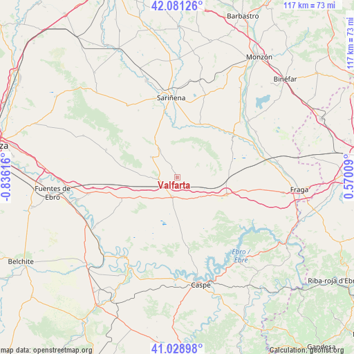
Valfarta GPS coordinates[2]
41° 33' 26.136" North, 0° 7' 58.944" West
| Map corner | latitude | longitude |
|---|---|---|
| Upper-left | 42.08126°, | -0.83616° |
| Center: | 41.55726°, | -0.13304° |
| Lower-right: | 41.02898°, | 0.57009° |
| Map W x H: | 117×117 km | = 72.7×72.7mi |
| max Lat: | 43.74134° ⇑37.6% North |
| Valfarta: | 41.55726° |
| min Lat: | ⇓62.4% South 27.64134° |
| min Long | Valfarta | max Long |
| -18.00367° | -0.13304° | 4.2899° |
| W 86.1%⇐ | ⇒13.9% E |
Elevation
Elevation of Valfarta is 369 m = 1211 ft, and this is 229 m = 751 ft below average elevation for this country.
| Max E: |
1682 m = 5518 ft | 70.9% |
| Avg. | 598 m = 1962 ft | |
| Valfarta | 369 m = 1211 ft | |
Min E: |
0 m = 0 ft | 29.1% |
See also: Spain elevation on elevation.city.
Geographical zone
Valfarta is located in North temperate zone (between Tropic of Cancer and the Arctic Circle). Distance of this Northern Tropic circle is 2014.8 km =1251.9 mi to South.| Distance of | km | miles | from Valfarta |
|---|---|---|---|
| North Pole | 5386.3 | 3346.9 | to North |
| Arctic Circle | 2780.4 | 1727.7 | to North |
| Tropic Cancer | 2014.8 | 1251.9 | to South |
| Equator | 4620.7 | 2871.2 | to South |


Nearby cities:
15 places around Valfarta: (largest is in red/bold)
• Albalatillo
19.8 km =12.3 mi,  355°
355°
• Alcolea de Cinca
27.5 km =17.1 mi,  49°
49°
• Ballobar
27.9 km =17.3 mi,  75°
75°
• Bujaraloz
6.8 km =4.2 mi,  194°
194°
• Candasnos
17.5 km =10.9 mi,  110°
110°
• Castejón de Monegros
11.2 km =7 mi,  307°
307°
• Castelflorite
28.8 km =17.9 mi,  18°
18°
• Chalamera
27.4 km =17 mi,  63°
63°
• La Almolda
6.5 km =4 mi,  266°
266°
• Monegrillo
25.2 km =15.7 mi,  291°
291°
• Ontiñena
22.7 km =14.1 mi, 54°
• Peñalba
10.1 km =6.3 mi,  128°
128°
• Sariñena
26.1 km =16.2 mi, 355°
• Sena
19.2 km =11.9 mi, 23°
• Villanueva de Sigena
20.4 km =12.7 mi,  30°
30°
Sources, notices
• [Note1] Compared only with cities in Spain existing in our database
• [Src1] Map data: © OpenStreetMap contributors (CC-BY-SA)
• [Src2] Other city data from geonames.org with taken over terms of usage.
• [Src3] Geographical zone / Annual Mean Temperature by Robert A. Rohde @ Wikipedia
