Peñalba geodata
Peñalba (Aragon) is a seat of a third-order administrative division; located in Spain in Europe/Madrid (GMT+2) time zone. With population of 723 people, there are 3363 cities with bigger population in this country. Compared to other cities in Spain, 60.9% of cities are located further ↓South; 86.8% of cities are located further ←West and 78.6% of cities have higher elevation than Peñalba. Note1


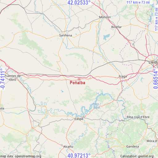
Peñalba GPS coordinates[2]
41° 30' 3.132" North, 0° 2' 16.728" West
| Map corner | latitude | longitude |
|---|---|---|
| Upper-left | 42.02533°, | -0.74111° |
| Center: | 41.50087°, | -0.03798° |
| Lower-right: | 40.97213°, | 0.66514° |
| Map W x H: | 117.1×117.1 km | = 72.8×72.8mi |
| max Lat: | 43.74134° ⇑39.1% North |
| Peñalba: | 41.50087° |
| min Lat: | ⇓60.9% South 27.64134° |
| min Long | Peñalba | max Long |
| -18.00367° | -0.03798° | 4.2899° |
| W 86.8%⇐ | ⇒13.2% E |
Elevation
Elevation of Peñalba is 246 m = 807 ft, and this is 352 m = 1155 ft below average elevation for this country.
| Max E: |
1682 m = 5518 ft | 78.6% |
| Avg. | 598 m = 1962 ft | |
| Peñalba | 246 m = 807 ft | |
Min E: |
0 m = 0 ft | 21.4% |
See also: Spain elevation on elevation.city.
Geographical zone
Peñalba is located in North temperate zone (between Tropic of Cancer and the Arctic Circle). Distance of this Northern Tropic circle is 2008.5 km =1248 mi to South.| Distance of | km | miles | from Peñalba |
|---|---|---|---|
| North Pole | 5392.6 | 3350.8 | to North |
| Arctic Circle | 2786.7 | 1731.6 | to North |
| Tropic Cancer | 2008.5 | 1248 | to South |
| Equator | 4614.5 | 2867.3 | to South |


Nearby cities:
15 places around Peñalba: (largest is in red/bold)
• Albalatillo
27.7 km =17.2 mi,  340°
340°
• Alcolea de Cinca
27.5 km =17.1 mi,  27°
27°
• Ballobar
23.3 km =14.5 mi,  55°
55°
• Bujaraloz
9.6 km =6 mi,  268°
268°
• Candasnos
8.5 km =5.3 mi,  89°
89°
• Castejón de Monegros
21.3 km =13.2 mi,  307°
307°
• Chalamera
24.8 km =15.4 mi,  42°
42°
• Chiprana
27.5 km =17.1 mi,  195°
195°
• La Almolda
15.6 km =9.7 mi,  292°
292°
• Ontiñena
22.2 km =13.8 mi, 28°
• Osso de Cinca
26.5 km =16.5 mi,  46°
46°
• Sena
23.9 km =14.9 mi,  359°
359°
• Valfarta
10.1 km =6.3 mi, 308°
• Villanueva de Sigena
24 km =14.9 mi,  5°
5°
• Zaidín
27.6 km =17.1 mi,  65°
65°
Sources, notices
• [Note1] Compared only with cities in Spain existing in our database
• [Src1] Map data: © OpenStreetMap contributors (CC-BY-SA)
• [Src2] Other city data from geonames.org with taken over terms of usage.
• [Src3] Geographical zone / Annual Mean Temperature by Robert A. Rohde @ Wikipedia
