Sariñena geodata
Sariñena (Aragon) is a seat of a third-order administrative division; located in Spain in Europe/Madrid (GMT+2) time zone. With population of 4,056 people, there are 1464 cities with bigger population in this country. Compared to other cities in Spain, 68.3% of cities are located further ↓South; 85.9% of cities are located further ←West and 75.4% of cities have higher elevation than Sariñena. Note1


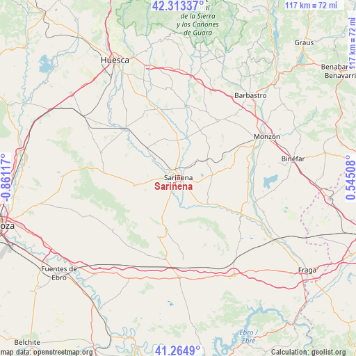
Sariñena GPS coordinates[2]
41° 47' 28.608" North, 0° 9' 28.944" West
| Map corner | latitude | longitude |
|---|---|---|
| Upper-left | 42.31337°, | -0.86117° |
| Center: | 41.79128°, | -0.15804° |
| Lower-right: | 41.2649°, | 0.54508° |
| Map W x H: | 116.6×116.6 km | = 72.5×72.5mi |
| max Lat: | 43.74134° ⇑31.7% North |
| Sariñena: | 41.79128° |
| min Lat: | ⇓68.3% South 27.64134° |
| min Long | Sariñena | max Long |
| -18.00367° | -0.15804° | 4.2899° |
| W 85.9%⇐ | ⇒14.1% E |
Elevation
Elevation of Sariñena is 293 m = 961 ft, and this is 305 m = 1001 ft below average elevation for this country.
| Max E: |
1682 m = 5518 ft | 75.4% |
| Avg. | 598 m = 1962 ft | |
| Sariñena | 293 m = 961 ft | |
Min E: |
0 m = 0 ft | 24.6% |
See also: Spain elevation on elevation.city.
Geographical zone
Sariñena is located in North temperate zone (between Tropic of Cancer and the Arctic Circle). Distance of this Northern Tropic circle is 2040.8 km =1268.1 mi to South.| Distance of | km | miles | from Sariñena |
|---|---|---|---|
| North Pole | 5360.3 | 3330.7 | to North |
| Arctic Circle | 2754.4 | 1711.5 | to North |
| Tropic Cancer | 2040.8 | 1268.1 | to South |
| Equator | 4646.8 | 2887.4 | to South |


Nearby cities:
15 places around Sariñena: (largest is in red/bold)
• Albalatillo
6.3 km =3.9 mi,  174°
174°
• Alberuela de Tubo
13.8 km =8.6 mi,  340°
340°
• Berbegal
22.7 km =14.1 mi,  34°
34°
• Capdesaso
6.1 km =3.8 mi, 340°
• Castejón de Monegros
20.4 km =12.7 mi,  199°
199°
• Castelflorite
11.4 km =7.1 mi,  83°
83°
• Huerto
15.6 km =9.7 mi,  357°
357°
• Lalueza
9.7 km =6 mi,  303°
303°
• Lanaja
14.5 km =9 mi,  260°
260°
• Peralta de Alcofea
17.3 km =10.7 mi, 25°
• Poleñino
15.3 km =9.5 mi, 304°
• Sena
12.7 km =7.9 mi,  131°
131°
• Torres de Alcanadre
20 km =12.4 mi,  11°
11°
• Tramaced
23.3 km =14.5 mi,  330°
330°
• Villanueva de Sigena
14.9 km =9.3 mi,  124°
124°
Sources, notices
• [Note1] Compared only with cities in Spain existing in our database
• [Src1] Map data: © OpenStreetMap contributors (CC-BY-SA)
• [Src2] Other city data from geonames.org with taken over terms of usage.
• [Src3] Geographical zone / Annual Mean Temperature by Robert A. Rohde @ Wikipedia
