Albalatillo geodata
Albalatillo (Aragon) is a seat of a third-order administrative division; located in Spain in Europe/Madrid (GMT+2) time zone. With population of 259 people, there are 4692 cities with bigger population in this country. Compared to other cities in Spain, 66.9% of cities are located further ↓South; 86% of cities are located further ←West and 77.6% of cities have higher elevation than Albalatillo. Note1


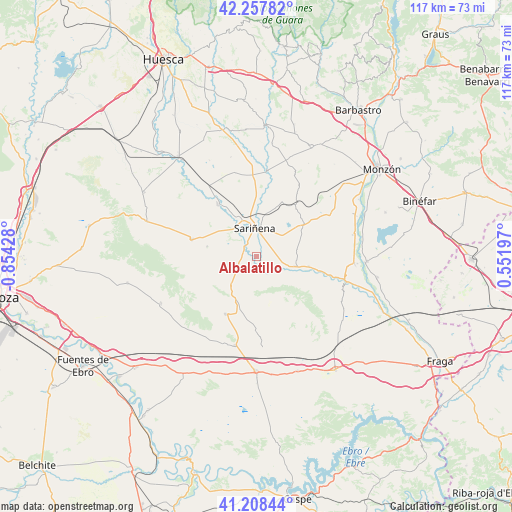
Albalatillo GPS coordinates[2]
41° 44' 6.972" North, 0° 9' 4.14" West
| Map corner | latitude | longitude |
|---|---|---|
| Upper-left | 42.25782°, | -0.85428° |
| Center: | 41.73527°, | -0.15115° |
| Lower-right: | 41.20844°, | 0.55197° |
| Map W x H: | 116.7×116.7 km | = 72.5×72.5mi |
| max Lat: | 43.74134° ⇑33.1% North |
| Albalatillo: | 41.73527° |
| min Lat: | ⇓66.9% South 27.64134° |
| min Long | Albalatillo | max Long |
| -18.00367° | -0.15115° | 4.2899° |
| W 86%⇐ | ⇒14% E |
Elevation
Elevation of Albalatillo is 261 m = 856 ft, and this is 337 m = 1106 ft below average elevation for this country.
| Max E: |
1682 m = 5518 ft | 77.6% |
| Avg. | 598 m = 1962 ft | |
| Albalatillo | 261 m = 856 ft | |
Min E: |
0 m = 0 ft | 22.4% |
See also: Spain elevation on elevation.city.
Geographical zone
Albalatillo is located in North temperate zone (between Tropic of Cancer and the Arctic Circle). Distance of this Northern Tropic circle is 2034.6 km =1264.2 mi to South.| Distance of | km | miles | from Albalatillo |
|---|---|---|---|
| North Pole | 5366.5 | 3334.6 | to North |
| Arctic Circle | 2760.6 | 1715.4 | to North |
| Tropic Cancer | 2034.6 | 1264.2 | to South |
| Equator | 4640.5 | 2883.5 | to South |


Nearby cities:
15 places around Albalatillo: (largest is in red/bold)
• Alberuela de Tubo
20 km =12.4 mi,  344°
344°
• Alcolea de Cinca
22.3 km =13.9 mi,  94°
94°
• Capdesaso
12.3 km =7.6 mi,  347°
347°
• Castejón de Monegros
15 km =9.3 mi,  209°
209°
• Castelflorite
13.1 km =8.1 mi,  55°
55°
• Huerto
21.8 km =13.5 mi,  356°
356°
• La Almolda
20.8 km =12.9 mi,  193°
193°
• Lalueza
14.4 km =8.9 mi,  323°
323°
• Lanaja
15.4 km =9.6 mi,  284°
284°
• Ontiñena
20.9 km =13 mi,  108°
108°
• Poleñino
19.9 km =12.4 mi, 318°
• Sariñena
6.3 km =3.9 mi, 354°
• Sena
9.3 km =5.8 mi,  103°
103°
• Valfarta
19.8 km =12.3 mi,  175°
175°
• Villanueva de Sigena
12 km =7.5 mi, 100°
Sources, notices
• [Note1] Compared only with cities in Spain existing in our database
• [Src1] Map data: © OpenStreetMap contributors (CC-BY-SA)
• [Src2] Other city data from geonames.org with taken over terms of usage.
• [Src3] Geographical zone / Annual Mean Temperature by Robert A. Rohde @ Wikipedia
