Arganda geodata
Arganda (Madrid) is a populated place; located in Spain in Europe/Madrid (GMT+2) time zone. With population of 51,489 people, there are 180 cities with bigger population in this country. Compared to other cities in Spain, 65.7% of cities are located further ↑North; 51.2% of cities are located further →East and 52.7% of cities have higher elevation than Arganda. Note1


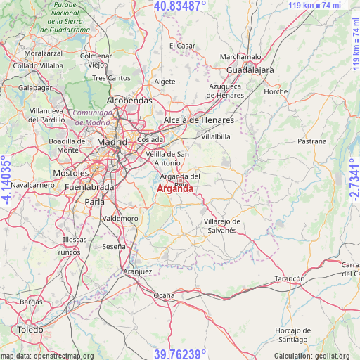
Arganda GPS coordinates[2]
40° 18' 2.736" North, 3° 26' 13.992" West
| Map corner | latitude | longitude |
|---|---|---|
| Upper-left | 40.83487°, | -4.14035° |
| Center: | 40.30076°, | -3.43722° |
| Lower-right: | 39.76239°, | -2.7341° |
| Map W x H: | 119.2×119.2 km | = 74.1×74.1mi |
| max Lat: | 43.74134° ⇑65.7% North |
| Arganda: | 40.30076° |
| min Lat: | ⇓34.3% South 27.64134° |
| min Long | Arganda | max Long |
| -18.00367° | -3.43722° | 4.2899° |
| W 48.8%⇐ | ⇒51.2% E |
Elevation
Elevation of Arganda is 626 m = 2054 ft, and this is 28 m = 92 ft above average elevation for this country.
| Max E: |
1682 m = 5518 ft | 52.7% |
| Arganda | 626 m 2054 ft | |
| Avg. | 598 m = 1962 ft | |
Min E: |
0 m = 0 ft | 47.3% |
See also: Arganda elevation on elevation.city.
Geographical zone
Arganda is located in North temperate zone (between Tropic of Cancer and the Arctic Circle). Distance of this Northern Tropic circle is 1875.1 km =1165.1 mi to South.| Distance of | km | miles | from Arganda |
|---|---|---|---|
| North Pole | 5526 | 3433.7 | to North |
| Arctic Circle | 2920.1 | 1814.5 | to North |
| Tropic Cancer | 1875.1 | 1165.1 | to South |
| Equator | 4481 | 2784.4 | to South |


Nearby cities:
15 places around Arganda: (largest is in red/bold)
• Campo Real
5.8 km =3.6 mi,  51°
51°
• Coslada
17.3 km =10.7 mi,  322°
322°
• Loeches
9.4 km =5.8 mi,  11°
11°
• Mejorada del Campo
10.9 km =6.8 mi,  339°
339°
• Morata de Tajuña
8.2 km =5.1 mi,  177°
177°
• Perales de Tajuña
10.7 km =6.6 mi,  136°
136°
• Pozuelo del Rey
12.4 km =7.7 mi,  55°
55°
• Rivas-Vaciamadrid
6.8 km =4.2 mi,  294°
294°
• San Fernando de Henares
15.9 km =9.9 mi,  329°
329°
• San Martín de la Vega
15.4 km =9.6 mi,  227°
227°
• Tielmes
12 km =7.5 mi,  120°
120°
• Torres de la Alameda
13.2 km =8.2 mi,  30°
30°
• Valdilecha
11.5 km =7.1 mi,  93°
93°
• Velilla de San Antonio
8.2 km =5.1 mi, 330°
• Villa de Vallecas
15.7 km =9.8 mi,  297°
297°
Sources, notices
• [Note1] Compared only with cities in Spain existing in our database
• [Src1] Map data: © OpenStreetMap contributors (CC-BY-SA)
• [Src2] Other city data from geonames.org with taken over terms of usage.
• [Src3] Geographical zone / Annual Mean Temperature by Robert A. Rohde @ Wikipedia
