Ambite geodata
Ambite (Madrid) is a seat of a third-order administrative division; located in Spain in Europe/Madrid (GMT+2) time zone. With population of 381 people, there are 4202 cities with bigger population in this country. Compared to other cities in Spain, 65.2% of cities are located further ↑North; 51.9% of cities are located further ←West and 52% of cities have lower elevation than Ambite. Note1


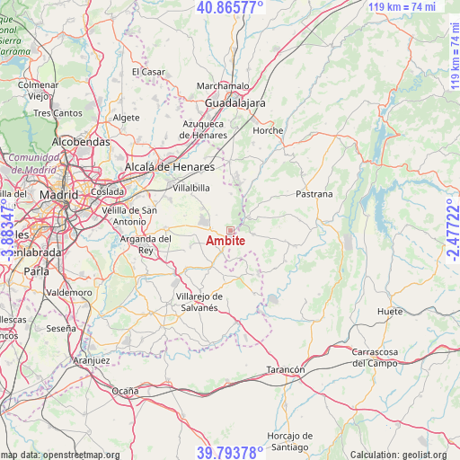
Ambite GPS coordinates[2]
40° 19' 54.84" North, 3° 10' 49.224" West
| Map corner | latitude | longitude |
|---|---|---|
| Upper-left | 40.86577°, | -3.88347° |
| Center: | 40.3319°, | -3.18034° |
| Lower-right: | 39.79378°, | -2.47722° |
| Map W x H: | 119.2×119.2 km | = 74.1×74.1mi |
| max Lat: | 43.74134° ⇑65.2% North |
| Ambite: | 40.3319° |
| min Lat: | ⇓34.8% South 27.64134° |
| min Long | Ambite | max Long |
| -18.00367° | -3.18034° | 4.2899° |
| W 51.9%⇐ | ⇒48.1% E |
Elevation
Elevation of Ambite is 680 m = 2231 ft, and this is 82 m = 269 ft above average elevation for this country.
| Max E: |
1682 m = 5518 ft | 48% |
| Ambite | 680 m 2231 ft | |
| Avg. | 598 m = 1962 ft | |
Min E: |
0 m = 0 ft | 52% |
See also: Spain elevation on elevation.city.
Geographical zone
Ambite is located in North temperate zone (between Tropic of Cancer and the Arctic Circle). Distance of this Northern Tropic circle is 1878.6 km =1167.3 mi to South.| Distance of | km | miles | from Ambite |
|---|---|---|---|
| North Pole | 5522.6 | 3431.6 | to North |
| Arctic Circle | 2916.7 | 1812.4 | to North |
| Tropic Cancer | 1878.6 | 1167.3 | to South |
| Equator | 4484.5 | 2786.5 | to South |


Nearby cities:
15 places around Ambite: (largest is in red/bold)
• Brea de Tajo
12.9 km =8 mi,  148°
148°
• Carabaña
9.8 km =6.1 mi,  208°
208°
• Corpa
12.2 km =7.6 mi,  326°
326°
• Escariche
13.5 km =8.4 mi,  52°
52°
• Fuentenovilla
8.3 km =5.2 mi,  65°
65°
• Loranca de Tajuña
13.8 km =8.6 mi,  25°
25°
• Mondéjar
6.3 km =3.9 mi,  101°
101°
• Nuevo Baztán
6.5 km =4 mi,  307°
307°
• Orusco
5.9 km =3.7 mi,  201°
201°
• Pezuela de las Torres
9.4 km =5.8 mi,  3°
3°
• Pozo de Almoguera
13.1 km =8.1 mi,  85°
85°
• Pozuelo del Rey
12.1 km =7.5 mi,  287°
287°
• Valdilecha
11.1 km =6.9 mi,  248°
248°
• Valverde de Alcalá
13.6 km =8.5 mi, 313°
• Villar del Olmo
4.6 km =2.9 mi,  273°
273°
Sources, notices
• [Note1] Compared only with cities in Spain existing in our database
• [Src1] Map data: © OpenStreetMap contributors (CC-BY-SA)
• [Src2] Other city data from geonames.org with taken over terms of usage.
• [Src3] Geographical zone / Annual Mean Temperature by Robert A. Rohde @ Wikipedia
