Ráfales geodata
Ráfales (Aragon) is a seat of a third-order administrative division; located in Spain in Europe/Madrid (GMT+2) time zone. With population of 175 people, there are 5220 cities with bigger population in this country. Compared to other cities in Spain, 55.3% of cities are located further ↑North; 87.1% of cities are located further ←West and 52.2% of cities have higher elevation than Ráfales. Note1


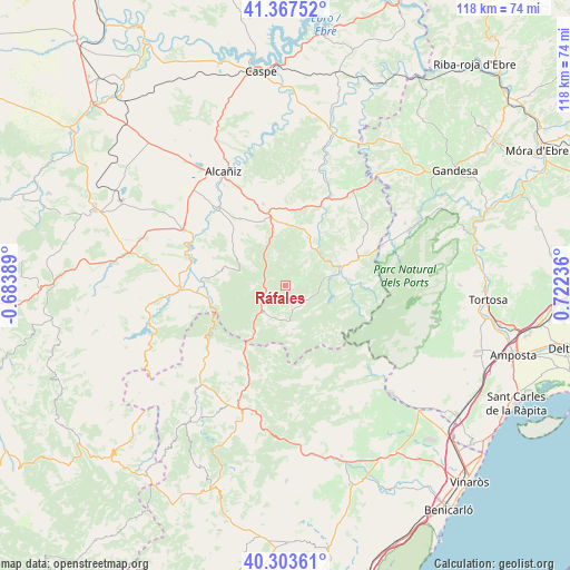
Ráfales GPS coordinates[2]
40° 50' 15.72" North, 0° 1' 9.228" East
| Map corner | latitude | longitude |
|---|---|---|
| Upper-left | 41.36752°, | -0.68389° |
| Center: | 40.8377°, | 0.01923° |
| Lower-right: | 40.30361°, | 0.72236° |
| Map W x H: | 118.3×118.3 km | = 73.5×73.5mi |
| max Lat: | 43.74134° ⇑55.3% North |
| Ráfales: | 40.8377° |
| min Lat: | ⇓44.7% South 27.64134° |
| min Long | Ráfales | max Long |
| -18.00367° | 0.01923° | 4.2899° |
| W 87.1%⇐ | ⇒12.9% E |
Elevation
Elevation of Ráfales is 634 m = 2080 ft, and this is 36 m = 118 ft above average elevation for this country.
| Max E: |
1682 m = 5518 ft | 52.2% |
| Ráfales | 634 m 2080 ft | |
| Avg. | 598 m = 1962 ft | |
Min E: |
0 m = 0 ft | 47.8% |
See also: Spain elevation on elevation.city.
Geographical zone
Ráfales is located in North temperate zone (between Tropic of Cancer and the Arctic Circle). Distance of this Northern Tropic circle is 1934.8 km =1202.2 mi to South.| Distance of | km | miles | from Ráfales |
|---|---|---|---|
| North Pole | 5466.3 | 3396.6 | to North |
| Arctic Circle | 2860.4 | 1777.4 | to North |
| Tropic Cancer | 1934.8 | 1202.2 | to South |
| Equator | 4540.7 | 2821.5 | to South |


Nearby cities:
15 places around Ráfales: (largest is in red/bold)
• Beseit / Beceite
13.8 km =8.6 mi,  92°
92°
• Fuentespalda
5.2 km =3.2 mi,  131°
131°
• Fórnoles
6.5 km =4 mi,  342°
342°
• Herbés
13.1 km =8.1 mi,  188°
188°
• La Ginebrosa
13.5 km =8.4 mi,  285°
285°
• Monroyo
7.2 km =4.5 mi,  219°
219°
• Peñarroya de Tastavíns
9.2 km =5.7 mi,  169°
169°
• Torre de Arcas
12.1 km =7.5 mi, 217°
• Torre del Compte
13.3 km =8.3 mi,  34°
34°
• Torrecilla de Alcañiz
16.5 km =10.3 mi,  325°
325°
• Torrevelilla
13 km =8.1 mi,  303°
303°
• Valdealgorfa
17.6 km =10.9 mi,  345°
345°
• Valdeltormo
17.5 km =10.9 mi,  17°
17°
• Valderrobres
12 km =7.5 mi,  71°
71°
• Valjunquera
12.8 km =8 mi,  2°
2°
Sources, notices
• [Note1] Compared only with cities in Spain existing in our database
• [Src1] Map data: © OpenStreetMap contributors (CC-BY-SA)
• [Src2] Other city data from geonames.org with taken over terms of usage.
• [Src3] Geographical zone / Annual Mean Temperature by Robert A. Rohde @ Wikipedia
