Valjunquera geodata
Valjunquera (Aragon) is a seat of a third-order administrative division; located in Spain in Europe/Madrid (GMT+2) time zone. With population of 414 people, there are 4096 cities with bigger population in this country. Compared to other cities in Spain, 52.7% of cities are located further ↑North; 87.1% of cities are located further ←West and 57.9% of cities have higher elevation than Valjunquera. Note1


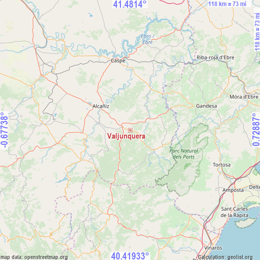
Valjunquera GPS coordinates[2]
40° 57' 9" North, 0° 1' 32.7" East
| Map corner | latitude | longitude |
|---|---|---|
| Upper-left | 41.4814°, | -0.67738° |
| Center: | 40.9525°, | 0.02575° |
| Lower-right: | 40.41933°, | 0.72887° |
| Map W x H: | 118.1×118.1 km | = 73.4×73.4mi |
| max Lat: | 43.74134° ⇑52.7% North |
| Valjunquera: | 40.9525° |
| min Lat: | ⇓47.3% South 27.64134° |
| min Long | Valjunquera | max Long |
| -18.00367° | 0.02575° | 4.2899° |
| W 87.1%⇐ | ⇒12.9% E |
Elevation
Elevation of Valjunquera is 553 m = 1814 ft, and this is 45 m = 148 ft below average elevation for this country.
| Max E: |
1682 m = 5518 ft | 57.9% |
| Avg. | 598 m = 1962 ft | |
| Valjunquera | 553 m = 1814 ft | |
Min E: |
0 m = 0 ft | 42.1% |
See also: Spain elevation on elevation.city.
Geographical zone
Valjunquera is located in North temperate zone (between Tropic of Cancer and the Arctic Circle). Distance of this Northern Tropic circle is 1947.6 km =1210.2 mi to South.| Distance of | km | miles | from Valjunquera |
|---|---|---|---|
| North Pole | 5453.6 | 3388.7 | to North |
| Arctic Circle | 2847.7 | 1769.5 | to North |
| Tropic Cancer | 1947.6 | 1210.2 | to South |
| Equator | 4553.5 | 2829.4 | to South |


Nearby cities:
15 places around Valjunquera: (largest is in red/bold)
• Alcañiz
17.2 km =10.7 mi,  309°
309°
• Calaceite
15.4 km =9.6 mi,  62°
62°
• Castelserás
14.8 km =9.2 mi,  282°
282°
• Cretas
15.8 km =9.8 mi,  99°
99°
• Fuentespalda
16.6 km =10.3 mi,  168°
168°
• Fórnoles
7 km =4.3 mi,  200°
200°
• La Ginebrosa
16.4 km =10.2 mi,  235°
235°
• Mazaleón
12.7 km =7.9 mi,  30°
30°
• Ráfales
12.8 km =8 mi,  182°
182°
• Torre del Compte
7.2 km =4.5 mi, 104°
• Torrecilla de Alcañiz
9.8 km =6.1 mi, 275°
• Torrevelilla
12.7 km =7.9 mi, 243°
• Valdealgorfa
6.6 km =4.1 mi, 310°
• Valdeltormo
6.2 km =3.9 mi,  51°
51°
• Valderrobres
14 km =8.7 mi,  129°
129°
Sources, notices
• [Note1] Compared only with cities in Spain existing in our database
• [Src1] Map data: © OpenStreetMap contributors (CC-BY-SA)
• [Src2] Other city data from geonames.org with taken over terms of usage.
• [Src3] Geographical zone / Annual Mean Temperature by Robert A. Rohde @ Wikipedia
