Fuentespalda geodata
Fuentespalda (Aragon) is a seat of a third-order administrative division; located in Spain in Europe/Madrid (GMT+2) time zone. With population of 379 people, there are 4212 cities with bigger population in this country. Compared to other cities in Spain, 56.1% of cities are located further ↑North; 87.4% of cities are located further ←West and 56.3% of cities have lower elevation than Fuentespalda. Note1


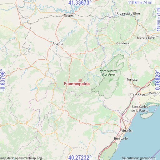
Fuentespalda GPS coordinates[2]
40° 48' 23.976" North, 0° 3' 54.612" East
| Map corner | latitude | longitude |
|---|---|---|
| Upper-left | 41.33673°, | -0.63796° |
| Center: | 40.80666°, | 0.06517° |
| Lower-right: | 40.27232°, | 0.76829° |
| Map W x H: | 118.4×118.4 km | = 73.6×73.6mi |
| max Lat: | 43.74134° ⇑56.1% North |
| Fuentespalda: | 40.80666° |
| min Lat: | ⇓43.9% South 27.64134° |
| min Long | Fuentespalda | max Long |
| -18.00367° | 0.06517° | 4.2899° |
| W 87.4%⇐ | ⇒12.6% E |
Elevation
Elevation of Fuentespalda is 718 m = 2356 ft, and this is 120 m = 394 ft above average elevation for this country.
| Max E: |
1682 m = 5518 ft | 43.7% |
| Fuentespalda | 718 m 2356 ft | |
| Avg. | 598 m = 1962 ft | |
Min E: |
0 m = 0 ft | 56.3% |
See also: Spain elevation on elevation.city.
Geographical zone
Fuentespalda is located in North temperate zone (between Tropic of Cancer and the Arctic Circle). Distance of this Northern Tropic circle is 1931.4 km =1200.1 mi to South.| Distance of | km | miles | from Fuentespalda |
|---|---|---|---|
| North Pole | 5469.8 | 3398.8 | to North |
| Arctic Circle | 2863.9 | 1779.5 | to North |
| Tropic Cancer | 1931.4 | 1200.1 | to South |
| Equator | 4537.3 | 2819.3 | to South |


Nearby cities:
15 places around Fuentespalda: (largest is in red/bold)
• Beseit / Beceite
10.3 km =6.4 mi,  74°
74°
• Castell de Cabres
16.4 km =10.2 mi,  186°
186°
• Cretas
18.3 km =11.4 mi,  42°
42°
• Fórnoles
11.3 km =7 mi,  329°
329°
• Herbés
11.2 km =7 mi,  211°
211°
• La Ginebrosa
18.3 km =11.4 mi,  292°
292°
• Monroyo
8.7 km =5.4 mi,  256°
256°
• Peñarroya de Tastavíns
6 km =3.7 mi,  200°
200°
• Ráfales
5.2 km =3.2 mi,  311°
311°
• Torre de Arcas
12.9 km =8 mi,  241°
241°
• Torre del Compte
14.9 km =9.3 mi,  14°
14°
• Torrevelilla
18.1 km =11.2 mi, 305°
• Valdeltormo
20.1 km =12.5 mi,  4°
4°
• Valderrobres
10.4 km =6.5 mi,  45°
45°
• Valjunquera
16.6 km =10.3 mi,  348°
348°
Sources, notices
• [Note1] Compared only with cities in Spain existing in our database
• [Src1] Map data: © OpenStreetMap contributors (CC-BY-SA)
• [Src2] Other city data from geonames.org with taken over terms of usage.
• [Src3] Geographical zone / Annual Mean Temperature by Robert A. Rohde @ Wikipedia
