Valdepiélagos geodata
Valdepiélagos (Madrid) is a seat of a third-order administrative division; located in Spain in Europe/Madrid (GMT+2) time zone. With population of 414 people, there are 4096 cities with bigger population in this country. Compared to other cities in Spain, 57% of cities are located further ↑North; 51.5% of cities are located further →East and 61.2% of cities have lower elevation than Valdepiélagos. Note1


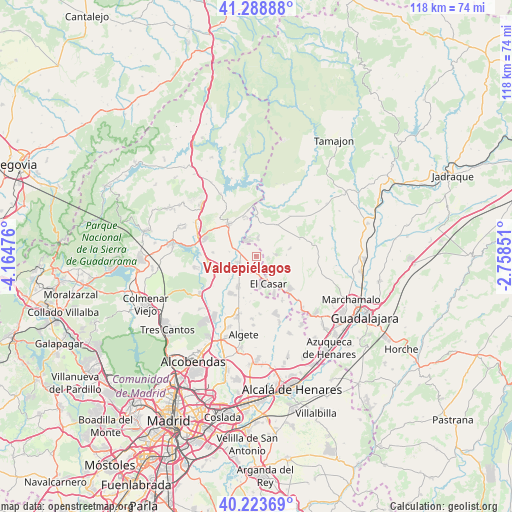
Valdepiélagos GPS coordinates[2]
40° 45' 30.312" North, 3° 27' 41.868" West
| Map corner | latitude | longitude |
|---|---|---|
| Upper-left | 41.28888°, | -4.16476° |
| Center: | 40.75842°, | -3.46163° |
| Lower-right: | 40.22369°, | -2.75851° |
| Map W x H: | 118.4×118.4 km | = 73.6×73.6mi |
| max Lat: | 43.74134° ⇑57% North |
| Valdepiélagos: | 40.75842° |
| min Lat: | ⇓43% South 27.64134° |
| min Long | Valdepiélagos | max Long |
| -18.00367° | -3.46163° | 4.2899° |
| W 48.5%⇐ | ⇒51.5% E |
Elevation
Elevation of Valdepiélagos is 752 m = 2467 ft, and this is 154 m = 505 ft above average elevation for this country.
| Max E: |
1682 m = 5518 ft | 38.8% |
| Valdepiélagos | 752 m 2467 ft | |
| Avg. | 598 m = 1962 ft | |
Min E: |
0 m = 0 ft | 61.2% |
See also: Spain elevation on elevation.city.
Geographical zone
Valdepiélagos is located in North temperate zone (between Tropic of Cancer and the Arctic Circle). Distance of this Northern Tropic circle is 1926 km =1196.8 mi to South.| Distance of | km | miles | from Valdepiélagos |
|---|---|---|---|
| North Pole | 5475.2 | 3402.1 | to North |
| Arctic Circle | 2869.3 | 1782.9 | to North |
| Tropic Cancer | 1926 | 1196.8 | to South |
| Equator | 4531.9 | 2816 | to South |


Nearby cities:
15 places around Valdepiélagos: (largest is in red/bold)
• Casa de Uceda
12.1 km =7.5 mi,  40°
40°
• El Molar
10.4 km =6.5 mi,  253°
253°
• El Vellón
10 km =6.2 mi,  274°
274°
• Galápagos
12.9 km =8 mi,  124°
124°
• Patones
11 km =6.8 mi,  349°
349°
• Pedrezuela
11.8 km =7.3 mi,  261°
261°
• Redueña
13.2 km =8.2 mi,  299°
299°
• Ribatejada
12.1 km =7.5 mi,  149°
149°
• Talamanca de Jarama
4.3 km =2.7 mi, 247°
• Torrelaguna
10 km =6.2 mi,  320°
320°
• Torremocha de Jarama
9.7 km =6 mi,  342°
342°
• Uceda
9 km =5.6 mi,  0°
0°
• Valdetorres de Jarama
8.3 km =5.2 mi,  210°
210°
• Villaseca de Uceda
11.6 km =7.2 mi,  54°
54°
• Viñuelas
10.9 km =6.8 mi,  69°
69°
Sources, notices
• [Note1] Compared only with cities in Spain existing in our database
• [Src1] Map data: © OpenStreetMap contributors (CC-BY-SA)
• [Src2] Other city data from geonames.org with taken over terms of usage.
• [Src3] Geographical zone / Annual Mean Temperature by Robert A. Rohde @ Wikipedia
