Galápagos geodata
Galápagos (Castille-La Mancha) is a seat of a third-order administrative division; located in Spain in Europe/Madrid (GMT+2) time zone. With population of 833 people, there are 3161 cities with bigger population in this country. Compared to other cities in Spain, 58.1% of cities are located further ↑North; 50% of cities are located further ←West and 59.3% of cities have lower elevation than Galápagos. Note1
Administrative division(s):
- Level 1: Castille-La Mancha
- Level 2: Provincia de Guadalajara
- Level 3: Galápagos


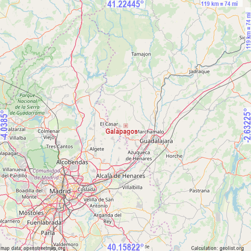
Galápagos GPS coordinates[2]
40° 41' 36.492" North, 3° 20' 7.332" West
| Map corner | latitude | longitude |
|---|---|---|
| Upper-left | 41.22445°, | -4.0385° |
| Center: | 40.69347°, | -3.33537° |
| Lower-right: | 40.15822°, | -2.63225° |
| Map W x H: | 118.6×118.6 km | = 73.7×73.7mi |
| max Lat: | 43.74134° ⇑58.1% North |
| Galápagos: | 40.69347° |
| min Lat: | ⇓41.9% South 27.64134° |
| min Long | Galápagos | max Long |
| -18.00367° | -3.33537° | 4.2899° |
| W 50%⇐ | ⇒50% E |
Elevation
Elevation of Galápagos is 740 m = 2428 ft, and this is 142 m = 466 ft above average elevation for this country.
| Max E: |
1682 m = 5518 ft | 40.7% |
| Galápagos | 740 m 2428 ft | |
| Avg. | 598 m = 1962 ft | |
Min E: |
0 m = 0 ft | 59.3% |
See also: Spain elevation on elevation.city.
Geographical zone
Galápagos is located in North temperate zone (between Tropic of Cancer and the Arctic Circle). Distance of this Northern Tropic circle is 1918.8 km =1192.3 mi to South.| Distance of | km | miles | from Galápagos |
|---|---|---|---|
| North Pole | 5482.4 | 3406.6 | to North |
| Arctic Circle | 2876.5 | 1787.4 | to North |
| Tropic Cancer | 1918.8 | 1192.3 | to South |
| Equator | 4524.7 | 2811.5 | to South |


Nearby cities:
15 places around Galápagos: (largest is in red/bold)
• Alovera
13.4 km =8.3 mi,  145°
145°
• Cabanillas del Campo
11.1 km =6.9 mi,  126°
126°
• Fresno de Torote
13.1 km =8.1 mi,  208°
208°
• Fuentelahiguera de Albatages
10.3 km =6.4 mi,  14°
14°
• Marchamalo
11.9 km =7.4 mi,  104°
104°
• Málaga del Fresno
12.9 km =8 mi,  36°
36°
• Quer
11 km =6.8 mi, 152°
• Ribatejada
5.6 km =3.5 mi,  234°
234°
• Torrejón del Rey
5.6 km =3.5 mi,  178°
178°
• Valdeavero
7.1 km =4.4 mi, 176°
• Valdeaveruelo
6.8 km =4.2 mi,  164°
164°
• Valdeolmos
11.6 km =7.2 mi,  237°
237°
• Valdepiélagos
12.9 km =8 mi,  304°
304°
• Villanueva de la Torre
12.8 km =8 mi,  165°
165°
• Viñuelas
11 km =6.8 mi,  357°
357°
Sources, notices
• [Note1] Compared only with cities in Spain existing in our database
• [Src1] Map data: © OpenStreetMap contributors (CC-BY-SA)
• [Src2] Other city data from geonames.org with taken over terms of usage.
• [Src3] Geographical zone / Annual Mean Temperature by Robert A. Rohde @ Wikipedia
