Ribatejada geodata
Ribatejada (Madrid) is a seat of a third-order administrative division; located in Spain in Europe/Madrid (GMT+2) time zone. With population of 437 people, there are 4033 cities with bigger population in this country. Compared to other cities in Spain, 58.6% of cities are located further ↑North; 50.7% of cities are located further →East and 59.9% of cities have lower elevation than Ribatejada. Note1


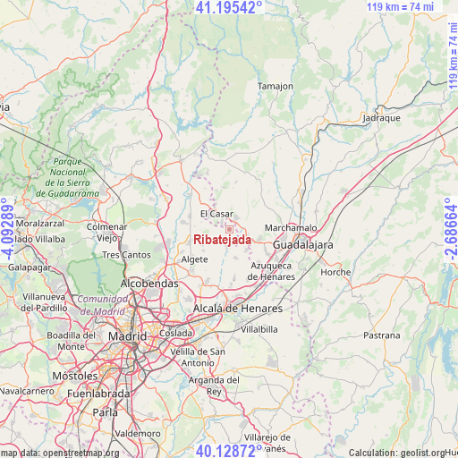
Ribatejada GPS coordinates[2]
40° 39' 51.12" North, 3° 23' 23.136" West
| Map corner | latitude | longitude |
|---|---|---|
| Upper-left | 41.19542°, | -4.09289° |
| Center: | 40.6642°, | -3.38976° |
| Lower-right: | 40.12872°, | -2.68664° |
| Map W x H: | 118.6×118.6 km | = 73.7×73.7mi |
| max Lat: | 43.74134° ⇑58.6% North |
| Ribatejada: | 40.6642° |
| min Lat: | ⇓41.4% South 27.64134° |
| min Long | Ribatejada | max Long |
| -18.00367° | -3.38976° | 4.2899° |
| W 49.3%⇐ | ⇒50.7% E |
Elevation
Elevation of Ribatejada is 744 m = 2441 ft, and this is 146 m = 479 ft above average elevation for this country.
| Max E: |
1682 m = 5518 ft | 40.1% |
| Ribatejada | 744 m 2441 ft | |
| Avg. | 598 m = 1962 ft | |
Min E: |
0 m = 0 ft | 59.9% |
See also: Spain elevation on elevation.city.
Geographical zone
Ribatejada is located in North temperate zone (between Tropic of Cancer and the Arctic Circle). Distance of this Northern Tropic circle is 1915.5 km =1190.2 mi to South.| Distance of | km | miles | from Ribatejada |
|---|---|---|---|
| North Pole | 5485.6 | 3408.6 | to North |
| Arctic Circle | 2879.7 | 1789.4 | to North |
| Tropic Cancer | 1915.5 | 1190.2 | to South |
| Equator | 4521.4 | 2809.5 | to South |


Nearby cities:
15 places around Ribatejada: (largest is in red/bold)
• Algete
11.8 km =7.3 mi,  230°
230°
• Camarma de Esteruelas
12.7 km =7.9 mi,  173°
173°
• Fresno de Torote
8.4 km =5.2 mi,  191°
191°
• Fuente el Saz
10.9 km =6.8 mi,  250°
250°
• Galápagos
5.6 km =3.5 mi,  54°
54°
• Meco
13.4 km =8.3 mi,  157°
157°
• Quer
11.7 km =7.3 mi,  124°
124°
• Talamanca de Jarama
13.3 km =8.3 mi,  311°
311°
• Torrejón del Rey
5.3 km =3.3 mi, 116°
• Valdeavero
6.3 km =3.9 mi,  127°
127°
• Valdeaveruelo
7.2 km =4.5 mi, 117°
• Valdeolmos
6 km =3.7 mi,  239°
239°
• Valdepiélagos
12.1 km =7.5 mi,  329°
329°
• Valdetorres de Jarama
10.8 km =6.7 mi,  287°
287°
• Villanueva de la Torre
12 km =7.5 mi,  139°
139°
Sources, notices
• [Note1] Compared only with cities in Spain existing in our database
• [Src1] Map data: © OpenStreetMap contributors (CC-BY-SA)
• [Src2] Other city data from geonames.org with taken over terms of usage.
• [Src3] Geographical zone / Annual Mean Temperature by Robert A. Rohde @ Wikipedia
