Alcocer geodata
Alcocer (Castille-La Mancha) is a seat of a third-order administrative division; located in Spain in Europe/Madrid (GMT+2) time zone. With population of 311 people, there are 4460 cities with bigger population in this country. Compared to other cities in Spain, 62.5% of cities are located further ↑North; 59.8% of cities are located further ←West and 66.6% of cities have lower elevation than Alcocer. Note1
Administrative division(s):
- Level 1: Castille-La Mancha
- Level 2: Provincia de Guadalajara
- Level 3: Alcocer


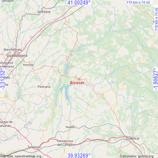
Alcocer GPS coordinates[2]
40° 28' 10.992" North, 2° 36' 33.84" West
| Map corner | latitude | longitude |
|---|---|---|
| Upper-left | 41.00249°, | -3.31252° |
| Center: | 40.46972°, | -2.6094° |
| Lower-right: | 39.93269°, | -1.90627° |
| Map W x H: | 119×118.9 km | = 73.9×73.9mi |
| max Lat: | 43.74134° ⇑62.5% North |
| Alcocer: | 40.46972° |
| min Lat: | ⇓37.5% South 27.64134° |
| min Long | Alcocer | max Long |
| -18.00367° | -2.6094° | 4.2899° |
| W 59.8%⇐ | ⇒40.2% E |
Elevation
Elevation of Alcocer is 789 m = 2589 ft, and this is 191 m = 627 ft above average elevation for this country.
| Max E: |
1682 m = 5518 ft | 33.4% |
| Alcocer | 789 m 2589 ft | |
| Avg. | 598 m = 1962 ft | |
Min E: |
0 m = 0 ft | 66.6% |
See also: Spain elevation on elevation.city.
Geographical zone
Alcocer is located in North temperate zone (between Tropic of Cancer and the Arctic Circle). Distance of this Northern Tropic circle is 1893.9 km =1176.8 mi to South.| Distance of | km | miles | from Alcocer |
|---|---|---|---|
| North Pole | 5507.3 | 3422.1 | to North |
| Arctic Circle | 2901.4 | 1802.8 | to North |
| Tropic Cancer | 1893.9 | 1176.8 | to South |
| Equator | 4499.8 | 2796 | to South |


Nearby cities:
15 places around Alcocer: (largest is in red/bold)
• Albendea
16.4 km =10.2 mi,  83°
83°
• Alcohujate
5.8 km =3.6 mi,  184°
184°
• Alique
13.3 km =8.3 mi,  347°
347°
• Canalejas del Arroyo
14.9 km =9.3 mi,  139°
139°
• Cañaveruelas
8.1 km =5 mi,  196°
196°
• Chillarón del Rey
15.9 km =9.9 mi,  334°
334°
• Escamilla
9.7 km =6 mi,  23°
23°
• Millana
5.3 km =3.3 mi,  37°
37°
• Pareja
10.1 km =6.3 mi,  340°
340°
• Sacedón
10.6 km =6.6 mi,  276°
276°
• Salmerón
12.9 km =8 mi,  49°
49°
• Tinajas
16.2 km =10.1 mi,  171°
171°
• Valdeolivas
14.4 km =8.9 mi,  73°
73°
• Villalba del Rey
13.9 km =8.6 mi,  190°
190°
• Villar del Infantado
11.1 km =6.9 mi,  98°
98°
Sources, notices
• [Note1] Compared only with cities in Spain existing in our database
• [Src1] Map data: © OpenStreetMap contributors (CC-BY-SA)
• [Src2] Other city data from geonames.org with taken over terms of usage.
• [Src3] Geographical zone / Annual Mean Temperature by Robert A. Rohde @ Wikipedia
