Tarazona geodata
Tarazona (Aragon) is a populated place; located in Spain in Europe/Madrid (GMT+2) time zone. With population of 11,211 people, there are 784 cities with bigger population in this country. Compared to other cities in Spain, 71% of cities are located further ↓South; 70.3% of cities are located further ←West and 62.5% of cities have higher elevation than Tarazona. Note1


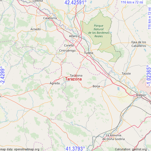
Tarazona GPS coordinates[2]
41° 54' 17.1" North, 1° 43' 36.408" West
| Map corner | latitude | longitude |
|---|---|---|
| Upper-left | 42.42591°, | -2.4299° |
| Center: | 41.90475°, | -1.72678° |
| Lower-right: | 41.3793°, | -1.02365° |
| Map W x H: | 116.4×116.4 km | = 72.3×72.3mi |
| max Lat: | 43.74134° ⇑29% North |
| Tarazona: | 41.90475° |
| min Lat: | ⇓71% South 27.64134° |
| min Long | Tarazona | max Long |
| -18.00367° | -1.72678° | 4.2899° |
| W 70.3%⇐ | ⇒29.7% E |
Elevation
Elevation of Tarazona is 493 m = 1617 ft, and this is 105 m = 344 ft below average elevation for this country.
| Max E: |
1682 m = 5518 ft | 62.5% |
| Avg. | 598 m = 1962 ft | |
| Tarazona | 493 m = 1617 ft | |
Min E: |
0 m = 0 ft | 37.5% |
See also: Spain elevation on elevation.city.
Geographical zone
Tarazona is located in North temperate zone (between Tropic of Cancer and the Arctic Circle). Distance of this Northern Tropic circle is 2053.5 km =1276 mi to South.| Distance of | km | miles | from Tarazona |
|---|---|---|---|
| North Pole | 5347.7 | 3322.9 | to North |
| Arctic Circle | 2741.8 | 1703.7 | to North |
| Tropic Cancer | 2053.5 | 1276 | to South |
| Equator | 4659.4 | 2895.2 | to South |


Nearby cities:
15 places around Tarazona: (largest is in red/bold)
• Ablitas
10.5 km =6.5 mi,  42°
42°
• Barillas
10.4 km =6.5 mi,  48°
48°
• Cascante
11 km =6.8 mi,  20°
20°
• Grisel
3.7 km =2.3 mi,  181°
181°
• Litago
10.3 km =6.4 mi,  192°
192°
• Lituénigo
8.3 km =5.2 mi,  200°
200°
• Malón
7 km =4.3 mi, 40°
• Monteagudo
7.8 km =4.8 mi,  27°
27°
• Novallas
5.5 km =3.4 mi, 23°
• Santa Cruz de Moncayo
3.5 km =2.2 mi,  224°
224°
• Torrellas
3.9 km =2.4 mi,  252°
252°
• Trasmoz
8.8 km =5.5 mi, 177°
• Tulebras
9.1 km =5.7 mi, 27°
• Vera de Moncayo
9.5 km =5.9 mi,  160°
160°
• Vierlas
4.5 km =2.8 mi,  56°
56°
Sources, notices
• [Note1] Compared only with cities in Spain existing in our database
• [Src1] Map data: © OpenStreetMap contributors (CC-BY-SA)
• [Src2] Other city data from geonames.org with taken over terms of usage.
• [Src3] Geographical zone / Annual Mean Temperature by Robert A. Rohde @ Wikipedia
