A Pobra do Brollon geodata
A Pobra do Brollon (Galicia) is a populated place; located in Spain in Europe/Madrid (GMT+2) time zone. With population of 2,372 people, there are 1955 cities with bigger population in this country. Compared to other cities in Spain, 88.4% of cities are located further ↓South; 95.2% of cities are located further →East and 69.7% of cities have higher elevation than A Pobra do Brollon. Note1
Administrative division(s):
- Level 1: Galicia
- Level 2: Provincia de Lugo
- Level 3: Pobra do Brollón, A


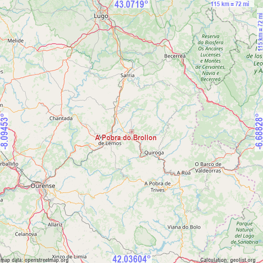
A Pobra do Brollon GPS coordinates[2]
42° 33' 22.032" North, 7° 23' 29.04" West
| Map corner | latitude | longitude |
|---|---|---|
| Upper-left | 43.0719°, | -8.09453° |
| Center: | 42.55612°, | -7.3914° |
| Lower-right: | 42.03604°, | -6.68828° |
| Map W x H: | 115.2×115.2 km | = 71.6×71.6mi |
| max Lat: | 43.74134° ⇑11.6% North |
| A Pobra do Brollon: | 42.55612° |
| min Lat: | ⇓88.4% South 27.64134° |
| min Long | A Pobra do Brol | max Long |
| -18.00367° | -7.3914° | 4.2899° |
| W 4.8%⇐ | ⇒95.2% E |
Elevation
Elevation of A Pobra do Brollon is 387 m = 1270 ft, and this is 211 m = 692 ft below average elevation for this country.
| Max E: |
1682 m = 5518 ft | 69.7% |
| Avg. | 598 m = 1962 ft | |
| A Pobra do Brollon | 387 m = 1270 ft | |
Min E: |
0 m = 0 ft | 30.3% |
See also: Spain elevation on elevation.city.
Geographical zone
A Pobra do Brollon is located in North temperate zone (between Tropic of Cancer and the Arctic Circle). Distance of this Northern Tropic circle is 2125.9 km =1321 mi to South.| Distance of | km | miles | from A Pobra do Brollon |
|---|---|---|---|
| North Pole | 5275.3 | 3277.9 | to North |
| Arctic Circle | 2669.4 | 1658.7 | to North |
| Tropic Cancer | 2125.9 | 1321 | to South |
| Equator | 4731.8 | 2940.2 | to South |


Nearby cities:
15 places around A Pobra do Brollon: (largest is in red/bold)
• Bóveda
10.3 km =6.4 mi,  317°
317°
• Castro
28.2 km =17.5 mi,  326°
326°
• Castro Caldelas
20.5 km =12.7 mi,  187°
187°
• Lobios
20.1 km =12.5 mi,  214°
214°
• Monforte de Lemos
10.8 km =6.7 mi,  249°
249°
• O Incio
9.2 km =5.7 mi,  21°
21°
• Pantón
17.6 km =10.9 mi,  255°
255°
• Paradela
27.4 km =17 mi, 328°
• Petín
29 km =18 mi,  131°
131°
• Pobra de Trives
26.6 km =16.5 mi,  154°
154°
• Quiroga
13 km =8.1 mi, 132°
• Samos
20.2 km =12.6 mi, 15°
• Sarria
25.1 km =15.6 mi,  355°
355°
• Sober
19.1 km =11.9 mi,  236°
236°
• Tríacastela
25.4 km =15.8 mi,  28°
28°
Sources, notices
• [Note1] Compared only with cities in Spain existing in our database
• [Src1] Map data: © OpenStreetMap contributors (CC-BY-SA)
• [Src2] Other city data from geonames.org with taken over terms of usage.
• [Src3] Geographical zone / Annual Mean Temperature by Robert A. Rohde @ Wikipedia
