Tramacastilla geodata
Tramacastilla (Aragon) is a seat of a third-order administrative division; located in Spain in Europe/Madrid (GMT+2) time zone. With population of 136 people, there are 5534 cities with bigger population in this country. Compared to other cities in Spain, 63.3% of cities are located further ↑North; 72.2% of cities are located further ←West and 98.3% of cities have lower elevation than Tramacastilla. Note1


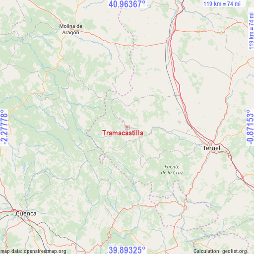
Tramacastilla GPS coordinates[2]
40° 25' 50.124" North, 1° 34' 28.776" West
| Map corner | latitude | longitude |
|---|---|---|
| Upper-left | 40.96367°, | -2.27778° |
| Center: | 40.43059°, | -1.57466° |
| Lower-right: | 39.89325°, | -0.87153° |
| Map W x H: | 119×119 km | = 73.9×73.9mi |
| max Lat: | 43.74134° ⇑63.3% North |
| Tramacastilla: | 40.43059° |
| min Lat: | ⇓36.7% South 27.64134° |
| min Long | Tramacastilla | max Long |
| -18.00367° | -1.57466° | 4.2899° |
| W 72.2%⇐ | ⇒27.8% E |
Elevation
Elevation of Tramacastilla is 1269 m = 4163 ft, and this is 671 m = 2201 ft above average elevation for this country.
| Max E: |
1682 m = 5518 ft | 1.7% |
| Tramacastilla | 1269 m 4163 ft | |
| Avg. | 598 m = 1962 ft | |
Min E: |
0 m = 0 ft | 98.3% |
See also: Spain elevation on elevation.city.
Geographical zone
Tramacastilla is located in North temperate zone (between Tropic of Cancer and the Arctic Circle). Distance of this Northern Tropic circle is 1889.5 km =1174.1 mi to South.| Distance of | km | miles | from Tramacastilla |
|---|---|---|---|
| North Pole | 5511.6 | 3424.7 | to North |
| Arctic Circle | 2905.7 | 1805.5 | to North |
| Tropic Cancer | 1889.5 | 1174.1 | to South |
| Equator | 4495.5 | 2793.4 | to South |


Nearby cities:
15 places around Tramacastilla: (largest is in red/bold)
• Albarracín
11.4 km =7.1 mi,  102°
102°
• Bronchales
9.1 km =5.7 mi,  352°
352°
• Calomarde
6.4 km =4 mi,  179°
179°
• Frías de Albarracín
10.9 km =6.8 mi,  198°
198°
• Griegos
11.6 km =7.2 mi,  268°
268°
• Guadalaviar
13 km =8.1 mi,  248°
248°
• Monterde de Albarracín
10.2 km =6.3 mi,  43°
43°
• Moscardón
11.3 km =7 mi,  163°
163°
• Orihuela del Tremedal
14.7 km =9.1 mi,  334°
334°
• Pozondón
17 km =10.6 mi,  31°
31°
• Royuela
7.8 km =4.8 mi,  138°
138°
• Saldón
17.1 km =10.6 mi,  133°
133°
• Terriente
16 km =9.9 mi, 157°
• Torres de Albarracín
3.6 km =2.2 mi, 96°
• Villar del Cobo
9.3 km =5.8 mi,  244°
244°
Sources, notices
• [Note1] Compared only with cities in Spain existing in our database
• [Src1] Map data: © OpenStreetMap contributors (CC-BY-SA)
• [Src2] Other city data from geonames.org with taken over terms of usage.
• [Src3] Geographical zone / Annual Mean Temperature by Robert A. Rohde @ Wikipedia
