Monterde de Albarracín geodata
Monterde de Albarracín (Aragon) is a seat of a third-order administrative division; located in Spain in Europe/Madrid (GMT+2) time zone. With population of 57 people, there are 6380 cities with bigger population in this country. Compared to other cities in Spain, 61.9% of cities are located further ↑North; 73% of cities are located further ←West and 98.4% of cities have lower elevation than Monterde de Albarracín. Note1
Administrative division(s):
- Level 1: Aragon
- Level 2: Provincia de Teruel
- Level 3: Monterde de Albarracín
Current local time in Monterde de Albarracín:
11:59 PM, ThursdayDifference from your time zone: hours


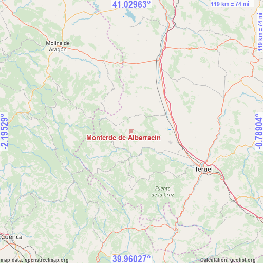
Monterde de Albarracín GPS coordinates[2]
40° 29' 49.488" North, 1° 29' 31.776" West
| Map corner | latitude | longitude |
|---|---|---|
| Upper-left | 41.02963°, | -2.19529° |
| Center: | 40.49708°, | -1.49216° |
| Lower-right: | 39.96027°, | -0.78904° |
| Map W x H: | 118.9×118.9 km | = 73.9×73.9mi |
| max Lat: | 43.74134° ⇑61.9% North |
| Monterde de Albarracín: | 40.49708° |
| min Lat: | ⇓38.1% South 27.64134° |
| min Long | Monterde de Alb | max Long |
| -18.00367° | -1.49216° | 4.2899° |
| W 73%⇐ | ⇒27% E |
Elevation
Elevation of Monterde de Albarracín is 1286 m = 4219 ft, and this is 688 m = 2257 ft above average elevation for this country.
| Max E: |
1682 m = 5518 ft | 1.6% |
| Monterde de Albarracín | 1286 m 4219 ft | |
| Avg. | 598 m = 1962 ft | |
Min E: |
0 m = 0 ft | 98.4% |
See also: Spain elevation on elevation.city.
Geographical zone
Monterde de Albarracín is located in North temperate zone (between Tropic of Cancer and the Arctic Circle). Distance of this Northern Tropic circle is 1896.9 km =1178.7 mi to South.| Distance of | km | miles | from Monterde de Albarracín |
|---|---|---|---|
| North Pole | 5504.2 | 3420.2 | to North |
| Arctic Circle | 2898.3 | 1800.9 | to North |
| Tropic Cancer | 1896.9 | 1178.7 | to South |
| Equator | 4502.9 | 2798 | to South |


Nearby cities:
15 places around Monterde de Albarracín: (largest is in red/bold)
• Alba
18.2 km =11.3 mi,  42°
42°
• Albarracín
10.7 km =6.6 mi,  157°
157°
• Almohaja
12.8 km =8 mi,  20°
20°
• Bronchales
8.3 km =5.2 mi,  281°
281°
• Calomarde
15.5 km =9.6 mi,  206°
206°
• Cella
18 km =11.2 mi,  105°
105°
• Gea de Albarracín
15.5 km =9.6 mi,  128°
128°
• Orihuela del Tremedal
14.6 km =9.1 mi,  293°
293°
• Peracense
16.1 km =10 mi,  6°
6°
• Pozondón
7.4 km =4.6 mi, 14°
• Royuela
13.3 km =8.3 mi,  187°
187°
• Ródenas
16.1 km =10 mi,  352°
352°
• Santa Eulalia
17 km =10.6 mi,  62°
62°
• Torres de Albarracín
8.5 km =5.3 mi,  203°
203°
• Tramacastilla
10.2 km =6.3 mi,  223°
223°
Sources, notices
• [Note1] Compared only with cities in Spain existing in our database
• [Src1] Map data: © OpenStreetMap contributors (CC-BY-SA)
• [Src2] Other city data from geonames.org with taken over terms of usage.
• [Src3] Geographical zone / Annual Mean Temperature by Robert A. Rohde @ Wikipedia
