Manzanillo geodata
Manzanillo (Castille and León) is a seat of a third-order administrative division; located in Spain in Europe/Madrid (GMT+2) time zone. With population of 46 people, there are 6506 cities with bigger population in this country. Compared to other cities in Spain, 63.1% of cities are located further ↓South; 62.5% of cities are located further →East and 67.2% of cities have lower elevation than Manzanillo. Note1
Administrative division(s):
- Level 1: Castille and León
- Level 2: Provincia de Valladolid
- Level 3: Manzanillo


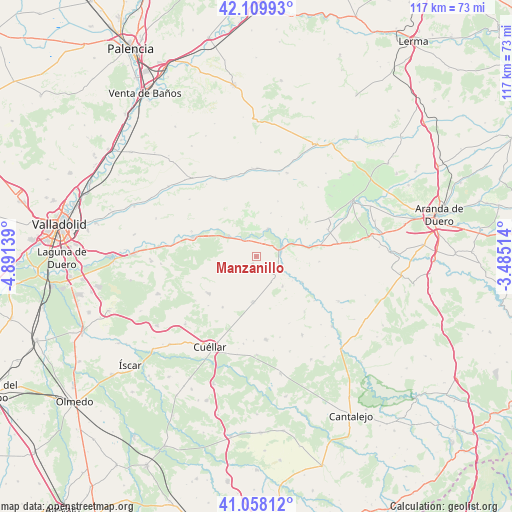
Manzanillo GPS coordinates[2]
41° 35' 10.212" North, 4° 11' 17.736" West
| Map corner | latitude | longitude |
|---|---|---|
| Upper-left | 42.10993°, | -4.89139° |
| Center: | 41.58617°, | -4.18826° |
| Lower-right: | 41.05812°, | -3.48514° |
| Map W x H: | 117×116.9 km | = 72.7×72.6mi |
| max Lat: | 43.74134° ⇑36.9% North |
| Manzanillo: | 41.58617° |
| min Lat: | ⇓63.1% South 27.64134° |
| min Long | Manzanillo | max Long |
| -18.00367° | -4.18826° | 4.2899° |
| W 37.5%⇐ | ⇒62.5% E |
Elevation
Elevation of Manzanillo is 793 m = 2602 ft, and this is 195 m = 640 ft above average elevation for this country.
| Max E: |
1682 m = 5518 ft | 32.8% |
| Manzanillo | 793 m 2602 ft | |
| Avg. | 598 m = 1962 ft | |
Min E: |
0 m = 0 ft | 67.2% |
See also: Spain elevation on elevation.city.
Geographical zone
Manzanillo is located in North temperate zone (between Tropic of Cancer and the Arctic Circle). Distance of this Northern Tropic circle is 2018 km =1253.9 mi to South.| Distance of | km | miles | from Manzanillo |
|---|---|---|---|
| North Pole | 5383.1 | 3344.9 | to North |
| Arctic Circle | 2777.2 | 1725.7 | to North |
| Tropic Cancer | 2018 | 1253.9 | to South |
| Equator | 4623.9 | 2873.2 | to South |


Nearby cities:
15 places around Manzanillo: (largest is in red/bold)
• Bocos de Duero
10.6 km =6.6 mi,  67°
67°
• Campaspero
10.5 km =6.5 mi,  183°
183°
• Canalejas de Peñafiel
9.1 km =5.7 mi,  138°
138°
• Curiel de Duero
9.6 km =6 mi,  48°
48°
• Fompedraza
6.7 km =4.2 mi,  147°
147°
• Langayo
2 km =1.2 mi,  205°
205°
• Olmos de Peñafiel
12.2 km =7.6 mi,  97°
97°
• Pesquera de Duero
6.7 km =4.2 mi,  23°
23°
• Peñafiel
6.4 km =4 mi, 74°
• Piñel de Abajo
10.4 km =6.5 mi, 19°
• Quintanilla de Arriba
4.5 km =2.8 mi,  326°
326°
• Roturas
10.8 km =6.7 mi,  32°
32°
• Rábano
12 km =7.5 mi,  119°
119°
• Torre de Peñafiel
10 km =6.2 mi, 123°
• Valbuena de Duero
10.8 km =6.7 mi,  306°
306°
Sources, notices
• [Note1] Compared only with cities in Spain existing in our database
• [Src1] Map data: © OpenStreetMap contributors (CC-BY-SA)
• [Src2] Other city data from geonames.org with taken over terms of usage.
• [Src3] Geographical zone / Annual Mean Temperature by Robert A. Rohde @ Wikipedia
