Campaspero geodata
Campaspero (Castille and León) is a seat of a third-order administrative division; located in Spain in Europe/Madrid (GMT+2) time zone. With population of 1,475 people, there are 2483 cities with bigger population in this country. Compared to other cities in Spain, 60.7% of cities are located further ↓South; 62.6% of cities are located further →East and 80.8% of cities have lower elevation than Campaspero. Note1
Administrative division(s):
- Level 1: Castille and León
- Level 2: Provincia de Valladolid
- Level 3: Campaspero


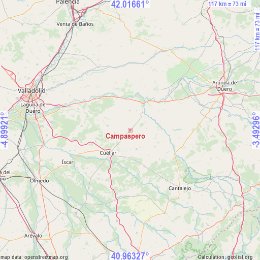
Campaspero GPS coordinates[2]
41° 29' 31.488" North, 4° 11' 45.888" West
| Map corner | latitude | longitude |
|---|---|---|
| Upper-left | 42.01661°, | -4.89921° |
| Center: | 41.49208°, | -4.19608° |
| Lower-right: | 40.96327°, | -3.49296° |
| Map W x H: | 117.1×117.1 km | = 72.8×72.8mi |
| max Lat: | 43.74134° ⇑39.3% North |
| Campaspero: | 41.49208° |
| min Lat: | ⇓60.7% South 27.64134° |
| min Long | Campaspero | max Long |
| -18.00367° | -4.19608° | 4.2899° |
| W 37.4%⇐ | ⇒62.6% E |
Elevation
Elevation of Campaspero is 905 m = 2969 ft, and this is 307 m = 1007 ft above average elevation for this country.
| Max E: |
1682 m = 5518 ft | 19.2% |
| Campaspero | 905 m 2969 ft | |
| Avg. | 598 m = 1962 ft | |
Min E: |
0 m = 0 ft | 80.8% |
See also: Spain elevation on elevation.city.
Geographical zone
Campaspero is located in North temperate zone (between Tropic of Cancer and the Arctic Circle). Distance of this Northern Tropic circle is 2007.6 km =1247.5 mi to South.| Distance of | km | miles | from Campaspero |
|---|---|---|---|
| North Pole | 5393.6 | 3351.4 | to North |
| Arctic Circle | 2787.7 | 1732.2 | to North |
| Tropic Cancer | 2007.6 | 1247.5 | to South |
| Equator | 4613.5 | 2866.7 | to South |


Nearby cities:
15 places around Campaspero: (largest is in red/bold)
• Aldeasoña
11.8 km =7.3 mi,  100°
100°
• Bahabón
7 km =4.3 mi,  260°
260°
• Canalejas de Peñafiel
7.7 km =4.8 mi,  61°
61°
• Cogeces del Monte
10.3 km =6.4 mi,  281°
281°
• Fompedraza
6.4 km =4 mi,  41°
41°
• Frumales
12.1 km =7.5 mi,  176°
176°
• Fuentesaúco de Fuentidueña
13.5 km =8.4 mi,  123°
123°
• Langayo
8.7 km =5.4 mi,  358°
358°
• Manzanillo
10.5 km =6.5 mi,  3°
3°
• Membibre de la Hoz
9.6 km =6 mi, 119°
• Olombrada
9.1 km =5.7 mi,  161°
161°
• Perosillo
11.9 km =7.4 mi, 157°
• Rábano
12.1 km =7.5 mi,  67°
67°
• Torre de Peñafiel
10.2 km =6.3 mi, 61°
• Torrescárcela
10.3 km =6.4 mi,  265°
265°
Sources, notices
• [Note1] Compared only with cities in Spain existing in our database
• [Src1] Map data: © OpenStreetMap contributors (CC-BY-SA)
• [Src2] Other city data from geonames.org with taken over terms of usage.
• [Src3] Geographical zone / Annual Mean Temperature by Robert A. Rohde @ Wikipedia
