Cuéllar geodata
Cuéllar (Castille and León) is a seat of a third-order administrative division; located in Spain in Europe/Madrid (GMT+2) time zone. With population of 9,588 people, there are 871 cities with bigger population in this country. Compared to other cities in Spain, 57.8% of cities are located further ↓South; 64% of cities are located further →East and 77.2% of cities have lower elevation than Cuéllar. Note1
Administrative division(s):
- Level 1: Castille and León
- Level 2: Provincia de Segovia
- Level 3: Cuéllar


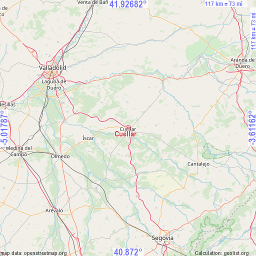
Cuéllar GPS coordinates[2]
41° 24' 5.58" North, 4° 18' 53.064" West
| Map corner | latitude | longitude |
|---|---|---|
| Upper-left | 41.92682°, | -5.01787° |
| Center: | 41.40155°, | -4.31474° |
| Lower-right: | 40.872°, | -3.61162° |
| Map W x H: | 117.3×117.3 km | = 72.9×72.9mi |
| max Lat: | 43.74134° ⇑42.2% North |
| Cuéllar: | 41.40155° |
| min Lat: | ⇓57.8% South 27.64134° |
| min Long | Cuéllar | max Long |
| -18.00367° | -4.31474° | 4.2899° |
| W 36%⇐ | ⇒64% E |
Elevation
Elevation of Cuéllar is 872 m = 2861 ft, and this is 274 m = 899 ft above average elevation for this country.
| Max E: |
1682 m = 5518 ft | 22.8% |
| Cuéllar | 872 m 2861 ft | |
| Avg. | 598 m = 1962 ft | |
Min E: |
0 m = 0 ft | 77.2% |
See also: Spain elevation on elevation.city.
Geographical zone
Cuéllar is located in North temperate zone (between Tropic of Cancer and the Arctic Circle). Distance of this Northern Tropic circle is 1997.5 km =1241.2 mi to South.| Distance of | km | miles | from Cuéllar |
|---|---|---|---|
| North Pole | 5403.6 | 3357.6 | to North |
| Arctic Circle | 2797.8 | 1738.5 | to North |
| Tropic Cancer | 1997.5 | 1241.2 | to South |
| Equator | 4603.4 | 2860.4 | to South |


Nearby cities:
15 places around Cuéllar: (largest is in red/bold)
• Bahabón
9.4 km =5.8 mi,  18°
18°
• Campaspero
14.1 km =8.8 mi,  44°
44°
• Chañe
11.8 km =7.3 mi,  233°
233°
• Cogeces del Monte
12.1 km =7.5 mi,  359°
359°
• Frumales
10.9 km =6.8 mi,  100°
100°
• Gómezserracín
12.5 km =7.8 mi,  184°
184°
• Mata de Cuéllar
13.1 km =8.1 mi,  267°
267°
• Olombrada
12.9 km =8 mi,  83°
83°
• Perosillo
14.5 km =9 mi,  93°
93°
• San Cristóbal de Cuéllar
7.5 km =4.7 mi, 273°
• San Miguel del Arroyo
13 km =8.1 mi,  290°
290°
• Sanchonuño
8.7 km =5.4 mi,  174°
174°
• Torrescárcela
9.2 km =5.7 mi, 357°
• Vallelado
9.3 km =5.8 mi, 271°
• Viloria
7.6 km =4.7 mi,  310°
310°
Sources, notices
• [Note1] Compared only with cities in Spain existing in our database
• [Src1] Map data: © OpenStreetMap contributors (CC-BY-SA)
• [Src2] Other city data from geonames.org with taken over terms of usage.
• [Src3] Geographical zone / Annual Mean Temperature by Robert A. Rohde @ Wikipedia
