Uruñuela geodata
Uruñuela (La Rioja) is a seat of a third-order administrative division; located in Spain in Europe/Madrid (GMT+2) time zone. With population of 778 people, there are 3256 cities with bigger population in this country. Compared to other cities in Spain, 86% of cities are located further ↓South; 58.5% of cities are located further ←West and 62% of cities have higher elevation than Uruñuela. Note1


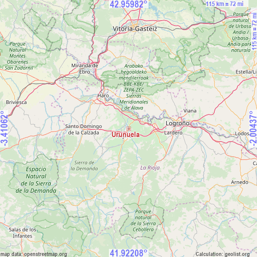
Uruñuela GPS coordinates[2]
42° 26' 35.16" North, 2° 42' 26.964" West
| Map corner | latitude | longitude |
|---|---|---|
| Upper-left | 42.95982°, | -3.41062° |
| Center: | 42.4431°, | -2.70749° |
| Lower-right: | 41.92208°, | -2.00437° |
| Map W x H: | 115.4×115.4 km | = 71.7×71.7mi |
| max Lat: | 43.74134° ⇑14% North |
| Uruñuela: | 42.4431° |
| min Lat: | ⇓86% South 27.64134° |
| min Long | Uruñuela | max Long |
| -18.00367° | -2.70749° | 4.2899° |
| W 58.5%⇐ | ⇒41.5% E |
Elevation
Elevation of Uruñuela is 499 m = 1637 ft, and this is 99 m = 325 ft below average elevation for this country.
| Max E: |
1682 m = 5518 ft | 62% |
| Avg. | 598 m = 1962 ft | |
| Uruñuela | 499 m = 1637 ft | |
Min E: |
0 m = 0 ft | 38% |
See also: Spain elevation on elevation.city.
Geographical zone
Uruñuela is located in North temperate zone (between Tropic of Cancer and the Arctic Circle). Distance of this Northern Tropic circle is 2113.3 km =1313.1 mi to South.| Distance of | km | miles | from Uruñuela |
|---|---|---|---|
| North Pole | 5287.8 | 3285.7 | to North |
| Arctic Circle | 2681.9 | 1666.5 | to North |
| Tropic Cancer | 2113.3 | 1313.1 | to South |
| Equator | 4719.2 | 2932.4 | to South |


Nearby cities:
15 places around Uruñuela: (largest is in red/bold)
• Alesón
4.4 km =2.7 mi,  160°
160°
• Arenzana de Abajo
6.4 km =4 mi,  188°
188°
• Arenzana de Arriba
6.3 km =3.9 mi,  170°
170°
• Azofra
8 km =5 mi,  254°
254°
• Bezares
8.6 km =5.3 mi, 159°
• Cenicero
6.7 km =4.2 mi,  50°
50°
• Hormilla
5.5 km =3.4 mi,  264°
264°
• Hormilleja
2.5 km =1.6 mi,  306°
306°
• Huércanos
1.9 km =1.2 mi,  150°
150°
• Manjarrés
6.3 km =3.9 mi, 155°
• Nájera
3.3 km =2.1 mi,  212°
212°
• San Asensio
6.9 km =4.3 mi,  329°
329°
• Torremontalbo
6.6 km =4.1 mi,  17°
17°
• Tricio
4.6 km =2.9 mi, 191°
• Ventosa
7.9 km =4.9 mi,  122°
122°
Sources, notices
• [Note1] Compared only with cities in Spain existing in our database
• [Src1] Map data: © OpenStreetMap contributors (CC-BY-SA)
• [Src2] Other city data from geonames.org with taken over terms of usage.
• [Src3] Geographical zone / Annual Mean Temperature by Robert A. Rohde @ Wikipedia
